Geolokalisieren

Topografische Karte Berg Mountain

Interaktive Karte

Klicken Sie auf die Karte, um die Höhe anzuzeigen.

Über diese Karte

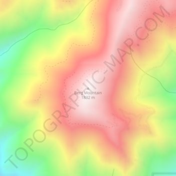
Name: Topografische Karte Berg Mountain, Höhe, Relief.

Ort: Berg Mountain, Idaho County, Idaho, USA (45.42540 -116.21824 45.42550 -116.21814)

Durchschnittliche Höhe: 1.420 m

Minimale Höhe: 861 m

Maximale Höhe: 1.827 m

Andere topografische Karten

Klicken Sie auf eine Karte, um ihre Topografie, ihre Höhe und ihr Relief anzuzeigen.

Pend Oreille River

USA > Idaho

Pend Oreille River, Bonner County, Idaho, 83822, USA

Durchschnittliche Höhe: 664 m

Henderson Peak

USA > Idaho

Henderson Peak, Teton County, Idaho, USA

Durchschnittliche Höhe: 2.276 m

Pack River

USA > Idaho

Pack River, Bonner County, Idaho, USA

Durchschnittliche Höhe: 677 m

Grouse

USA > Idaho > Grouse

Grouse, Custer County, Idaho, USA

Durchschnittliche Höhe: 1.913 m

Garden City

USA > Idaho > Garden City

Garden City, Ada County, Idaho, 83614, USA

Durchschnittliche Höhe: 852 m

Spencer Butte

USA > Idaho

Spencer Butte, Owyhee County, Idaho, USA

Durchschnittliche Höhe: 1.626 m

Feltham

USA > Idaho > Feltham

Feltham, Washington County, Idaho, USA

Durchschnittliche Höhe: 652 m

Grays Peak

USA > Idaho

Grays Peak, Valley County, Idaho, USA

Durchschnittliche Höhe: 2.287 m

Alice Lake

USA > Idaho

Alice Lake, Trail 095, Custer County, Idaho, USA

Durchschnittliche Höhe: 2.747 m

Deception Point

USA > Idaho

Deception Point, Clearwater County, Idaho, USA

Durchschnittliche Höhe: 1.381 m

Breezy Point

USA > Idaho

Breezy Point, Shoshone County, Idaho, USA

Durchschnittliche Höhe: 1.739 m

Garwood

USA > Idaho > Garwood

Garwood, Kootenai County, Idaho, 83835-9460, USA

Durchschnittliche Höhe: 716 m