
Topografische Karte Piner
Interaktive Karte
Klicken Sie auf die Karte, um die Höhe anzuzeigen.
Über diese Karte
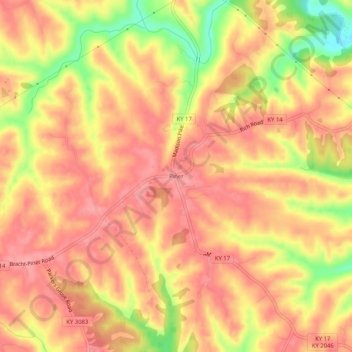
Name: Topografische Karte Piner, Höhe, Relief.
Ort: Piner, Kenton County, Kentucky, 41163, United States (38.81145 -84.55577 38.85145 -84.51577)
Durchschnittliche Höhe: 251 m
Minimale Höhe: 188 m
Maximale Höhe: 279 m
Andere topografische Karten
Klicken Sie auf eine Karte, um ihre Topografie, ihre Höhe und ihr Relief anzuzeigen.
Fort Wright
United States > Kentucky > Kenton County
Fort Wright, Kenton County, Kentucky, United States
Durchschnittliche Höhe: 219 m
Pride Park
United States > Kentucky > Kenton County > Taylor Mill
Pride Park, Taylor Mill, Kenton County, Kentucky, United States
Durchschnittliche Höhe: 237 m
Covington
United States > Kentucky > Kenton County
Covington, Kenton County, Kentucky, United States
Durchschnittliche Höhe: 215 m
Independence
United States > Kentucky > Kenton County
Independence, Kenton County, Kentucky, 41051, United States
Durchschnittliche Höhe: 254 m
Erlanger
United States > Kentucky > Kenton County
Erlanger, Kenton County, Kentucky, 41018, United States
Durchschnittliche Höhe: 258 m
Daniel Carter Beard Boyhood Home
United States > Kentucky > Kenton County > Covington
Daniel Carter Beard Boyhood Home, Licking Riverside Historic District, Covington, Kenton County, Kentucky, United States
Durchschnittliche Höhe: 157 m
Taylor Mill
United States > Kentucky > Kenton County
Taylor Mill, Kenton County, Kentucky, 41015, United States
Durchschnittliche Höhe: 211 m
Edgewood
United States > Kentucky > Kenton County
Edgewood, Kenton County, Kentucky, United States
Durchschnittliche Höhe: 258 m
Austinburg
United States > Kentucky > Kenton County > Covington > Austinburg
Austinburg, Covington, Kenton County, Kentucky, 41014, United States
Durchschnittliche Höhe: 178 m
Fort Mitchell
United States > Kentucky > Kenton County
Fort Mitchell, Kenton County, Kentucky, United States
Durchschnittliche Höhe: 235 m
Crestview Hills
United States > Kentucky > Kenton County
Crestview Hills, Kenton County, Kentucky, United States
Durchschnittliche Höhe: 259 m