
Topografische Karte Lamia Municipality
Interaktive Karte
Klicken Sie auf die Karte, um die Höhe anzuzeigen.
Über diese Karte
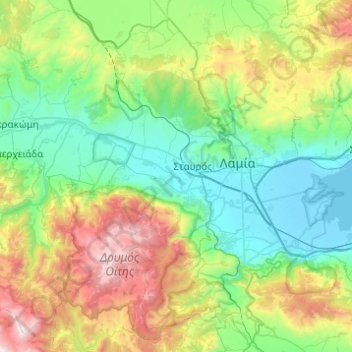
Name: Topografische Karte Lamia Municipality, Höhe, Relief.
Durchschnittliche Höhe: 611 m
Minimale Höhe: -4 m
Maximale Höhe: 2.264 m
Andere topografische Karten
Klicken Sie auf eine Karte, um ihre Topografie, ihre Höhe und ihr Relief anzuzeigen.
Loutra Thermopilon
Greece > Thessaly and Central Greece > Phthiotis Regional Unit > Municipal Unit of Lamia
Loutra Thermopilon, Thermopylae Community, Municipal Unit of Lamia, Lamia Municipality, Phthiotis Regional Unit, Central Greece, Thessaly and Central Greece, 350 09, Greece
Durchschnittliche Höhe: 241 m
Παρνασσός
Greece > Thessaly and Central Greece > Phthiotis Regional Unit > Municipal Unit of Tithorea
Παρνασσός, Municipal Unit of Tithorea, Amfikleia-Elateia Municipality, Phthiotis Regional Unit, Central Greece, Thessaly and Central Greece, Greece
Durchschnittliche Höhe: 2.125 m