
Topografische Karte Rineyville
Interaktive Karte
Klicken Sie auf die Karte, um die Höhe anzuzeigen.
Über diese Karte
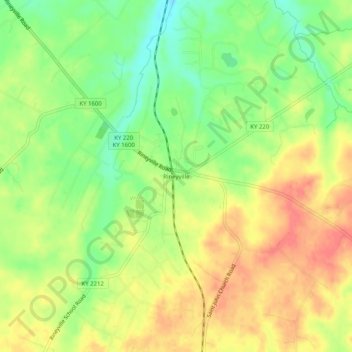
Name: Topografische Karte Rineyville, Höhe, Relief.
Ort: Rineyville, Hardin County, Kentucky, 40162, United States (37.72951 -85.98996 37.76951 -85.94996)
Durchschnittliche Höhe: 243 m
Minimale Höhe: 212 m
Maximale Höhe: 270 m
Andere topografische Karten
Klicken Sie auf eine Karte, um ihre Topografie, ihre Höhe und ihr Relief anzuzeigen.
Vine Grove
United States > Kentucky > Hardin County
Vine Grove, Hardin County, Kentucky, United States
Durchschnittliche Höhe: 218 m
Sonora
United States > Kentucky > Hardin County
Sonora, Hardin County, Kentucky, United States
Durchschnittliche Höhe: 221 m
Saint John
United States > Kentucky > Hardin County
Saint John, Hardin County, Kentucky, 42724, United States
Durchschnittliche Höhe: 237 m
Nolin
United States > Kentucky > Hardin County
Nolin, Hardin County, Kentucky, 42740, United States
Durchschnittliche Höhe: 210 m
Howe Valley
United States > Kentucky > Hardin County
Howe Valley, Hardin County, Kentucky, United States
Durchschnittliche Höhe: 221 m
Hardin Springs
United States > Kentucky > Hardin County
Hardin Springs, Hardin County, Kentucky, 40145, United States
Durchschnittliche Höhe: 195 m
Limp
United States > Kentucky > Hardin County
Limp, Hardin County, Kentucky, United States
Durchschnittliche Höhe: 211 m
White Mills
United States > Kentucky > Hardin County
White Mills, Hardin County, Kentucky, 42788, United States
Durchschnittliche Höhe: 195 m
Glendale
United States > Kentucky > Hardin County
Glendale, Hardin County, Kentucky, 42740, United States
Durchschnittliche Höhe: 212 m
West Point
United States > Kentucky > Hardin County
West Point, Hardin County, Kentucky, United States
Durchschnittliche Höhe: 163 m
Eastview
United States > Kentucky > Hardin County
Eastview, Hardin County, Kentucky, 42732, United States
Durchschnittliche Höhe: 231 m
Cecilia
United States > Kentucky > Hardin County
Cecilia, Hardin County, Kentucky, 42724, United States
Durchschnittliche Höhe: 221 m
Stephensburg
United States > Kentucky > Hardin County
Stephensburg, Hardin County, Kentucky, 42724, United States
Durchschnittliche Höhe: 216 m
Star Mills
United States > Kentucky > Hardin County
Star Mills, Hardin County, Kentucky, United States
Durchschnittliche Höhe: 205 m
Old Stephensburg
United States > Kentucky > Hardin County
Old Stephensburg, Hardin County, Kentucky, United States
Durchschnittliche Höhe: 220 m
Elizabethtown
United States > Kentucky > Hardin County
Elizabethtown, Hardin County, Kentucky, 42701, United States
Durchschnittliche Höhe: 241 m
Colesburg
United States > Kentucky > Hardin County
Colesburg, Hardin County, Kentucky, United States
Durchschnittliche Höhe: 188 m
Upton
United States > Kentucky > Hardin County
Upton, Hardin County, Kentucky, United States
Durchschnittliche Höhe: 230 m
Kraft
United States > Kentucky > Hardin County > Kraft
Kraft, Hardin County, Kentucky, 40162, United States
Durchschnittliche Höhe: 247 m
Indian Hills
United States > Kentucky > Hardin County > Elizabethtown
Indian Hills, Elizabethtown, Hardin County, Kentucky, 42701, United States
Durchschnittliche Höhe: 238 m
Elizabethtown
United States > Kentucky > Hardin County > Elizabethtown > Elizabethtown
Elizabethtown, Hardin County, Kentucky, 42701, United States
Durchschnittliche Höhe: 221 m