
Topografische Karte Cubillas de Arbás
Interaktive Karte
Klicken Sie auf die Karte, um die Höhe anzuzeigen.
Über diese Karte
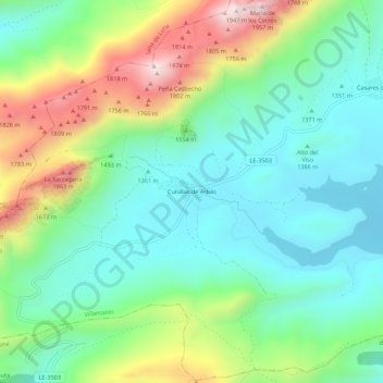
Name: Topografische Karte Cubillas de Arbás, Höhe, Relief.
Ort: Cubillas de Arbás, Villamanín, León, Castilla y León, España (42.90850 -5.82474 42.94850 -5.78474)
Durchschnittliche Höhe: 1.485 m
Minimale Höhe: 1.276 m
Maximale Höhe: 1.942 m
Andere topografische Karten
Klicken Sie auf eine Karte, um ihre Topografie, ihre Höhe und ihr Relief anzuzeigen.
Pendilla de Arbas
España > Castilla y León > Villamanín
Pendilla de Arbas, Villamanín, León, Castilla y León, 24690, España
Durchschnittliche Höhe: 1.570 m
Arbas del Puerto
España > Castilla y León > Villamanín
Arbas del Puerto, Villamanín, León, Castilla y León, 24690, España
Durchschnittliche Höhe: 1.471 m
Puerto de Pajares
España > Castilla y León > Villamanín
Puerto de Pajares, Villamanín, La Robla, Castilla y León, 33693, España
Durchschnittliche Höhe: 1.361 m
Valle Vainilla
España > Castilla y León > Villamanín > Busdongo
Valle Vainilla, Busdongo, Villamanín, La Robla, Castilla y León, 24690, España
Durchschnittliche Höhe: 1.414 m