
Topografische Karte Serra de Tramuntana
Interaktive Karte
Klicken Sie auf die Karte, um die Höhe anzuzeigen.
Über diese Karte
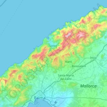
Name: Topografische Karte Serra de Tramuntana, Höhe, Relief.
Ort: Serra de Tramuntana, Balearic Islands, Spain (39.62579 2.44363 39.84761 2.96694)
Durchschnittliche Höhe: 175 m
Minimale Höhe: -1 m
Maximale Höhe: 1.418 m
The climate in the Tramuntana Range is significantly wetter than the rest of the island, recording as much as 1507 mm (59.3 inches) of precipitation per year, in comparison with some other parts of the island where annual rainfall is less than 400mm (15 inch). It is also cooler due to the altitude, and a few days of snow are not unusual during winter.
Andere topografische Karten
Klicken Sie auf eine Karte, um ihre Topografie, ihre Höhe und ihr Relief anzuzeigen.
Pollença
Spain > Balearic Islands > Serra de Tramuntana
Pollença, Serra de Tramuntana, Balearic Islands, Spain
Durchschnittliche Höhe: 115 m
Pollença
Spain > Balearic Islands > Serra de Tramuntana > Pollença > Pollença
Pollença, Serra de Tramuntana, Balearic Islands, 07460, Spain
Durchschnittliche Höhe: 156 m