
Topografische Karte Las Médulas
Interaktive Karte
Klicken Sie auf die Karte, um die Höhe anzuzeigen.
Über diese Karte
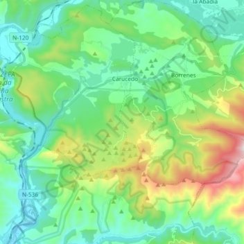
Name: Topografische Karte Las Médulas, Höhe, Relief.
Durchschnittliche Höhe: 631 m
Minimale Höhe: 361 m
Maximale Höhe: 1.405 m
The spectacular landscape of Las Médulas resulted from the ruina montium (wrecking of the mountains), a Roman mining technique described by Pliny the Elder in 77 AD. The technique employed was a type of hydraulic mining which involved undermining a mountain with large quantities of water. The water was supplied by interbasin transfer. At least seven long aqueducts tapped the streams of the La Cabrera district (where the rainfall in the mountains is relatively high) at a range of altitudes. The same aqueducts were used to wash the extensive alluvial gold deposits.