
Topografische Karte Avalanche Lake
Interaktive Karte
Klicken Sie auf die Karte, um die Höhe anzuzeigen.
Über diese Karte
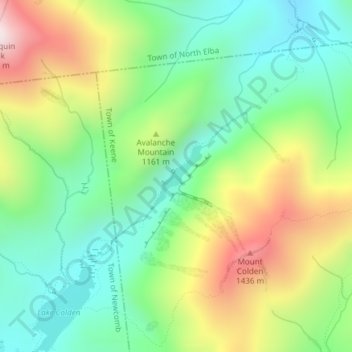
Name: Topografische Karte Avalanche Lake, Höhe, Relief.
Durchschnittliche Höhe: 1.066 m
Minimale Höhe: 788 m
Maximale Höhe: 1.541 m
Andere topografische Karten
Klicken Sie auf eine Karte, um ihre Topografie, ihre Höhe und ihr Relief anzuzeigen.
Staten Island
Staten Island, Richmond County, New York, USA
Durchschnittliche Höhe: 11 m
Chestnut Creek
Chestnut Creek, Town of Neversink, Sullivan County, New York, 12765, USA
Durchschnittliche Höhe: 470 m
Gooseberry Hill
Gooseberry Hill, Essex County, New York, 12872, USA
Durchschnittliche Höhe: 304 m
City of Saratoga Springs
USA > New York > City of Saratoga Springs
City of Saratoga Springs, Saratoga County, New York, USA
Durchschnittliche Höhe: 95 m
Mount Warren
Mount Warren, Town of Bovina, Delaware County, New York, USA
Durchschnittliche Höhe: 677 m
Twin Mountains
Twin Mountains, Franklin County, New York, USA
Durchschnittliche Höhe: 553 m
West Bay Shore
USA > New York > West Bay Shore
West Bay Shore, Suffolk County, New York, USA
Durchschnittliche Höhe: 7 m
Roosevelt Island
USA > New York > New York City
Roosevelt Island, Manhattan Community Board 8, New York County, New York City, New York, 10044, USA
Durchschnittliche Höhe: 13 m
Adirondack
USA > New York > Adirondack
Adirondack, Town of Horicon, Warren County, New York, 12808, USA
Durchschnittliche Höhe: 294 m
Big Bear Mountain
Big Bear Mountain, Town of Johnsburg, Warren County, New York, USA
Durchschnittliche Höhe: 616 m
Niagara Falls
USA > New York > Niagara Falls
Niagara Falls, Niagara County, New York, USA
Durchschnittliche Höhe: 180 m
Crows Nest
Crows Nest, Saint Lawrence County, New York, USA
Durchschnittliche Höhe: 114 m
Lake Champlain
Lake Champlain, Essex County, New York, USA
Durchschnittliche Höhe: 341 m
Livingston Island
Livingston Island, Town of Philipstown, Putnam County, New York, 10922, USA
Durchschnittliche Höhe: 156 m