
Topografische Karte Cortina
Interaktive Karte
Klicken Sie auf die Karte, um die Höhe anzuzeigen.
Über diese Karte
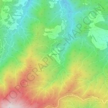
Name: Topografische Karte Cortina, Höhe, Relief.
Ort: Cortina, Castel San Niccolò, Arezzo, Tuscany, 52018, Italy (43.68703 11.66585 43.72703 11.70585)
Durchschnittliche Höhe: 771 m
Minimale Höhe: 443 m
Maximale Höhe: 1.273 m
Andere topografische Karten
Klicken Sie auf eine Karte, um ihre Topografie, ihre Höhe und ihr Relief anzuzeigen.
Loro Ciuffenna
Loro Ciuffenna, Unione dei Comuni del Pratomagno, Arezzo, Tuscany, 52024, Italy
Durchschnittliche Höhe: 602 m