
Topografische Karte Ruaudin
Interaktive Karte
Klicken Sie auf die Karte, um die Höhe anzuzeigen.
Über diese Karte
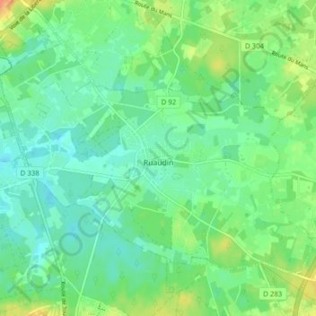
Name: Topografische Karte Ruaudin, Höhe, Relief.
Durchschnittliche Höhe: 59 m
Minimale Höhe: 46 m
Maximale Höhe: 84 m
Ruaudin (French pronunciation: [ʁɥodɛ̃]) is a commune in the department of Sarthe in the Pays de la Loire Region of north-western France. Ruaudin is located in the canton of Écommoy and the arrondissement of Le Mans. The INSEE code is 72260 and the postal code is 72230. The minimum elevation is 47 meters and the maximum elevation is 66 meters. The town has a total surface area of 13.78 km2 (5.32 sq mi). The population of Ruaudin was 2,862 in 1999, 3,322 in 2007 and 3,418 in 2017. The nearest town from Ruaudin is Mulsanne, which is just 4.8 kilometers away. Ruaudin gained district hood in 1787. The village had 144 active establishments at the end of 2018. There were 22 documented births in 2019.
Andere topografische Karten
Klicken Sie auf eine Karte, um ihre Topografie, ihre Höhe und ihr Relief anzuzeigen.
Saint-Georges-le-Gaultier
France > Pays de la Loire > Sarthe
Saint-Georges-le-Gaultier, Mamers, Sarthe, Pays de la Loire, Metropolitan France, 72130, France
Durchschnittliche Höhe: 135 m
Fontenay-sur-Vègre
France > Pays de la Loire > Sarthe
Fontenay-sur-Vègre, La Flèche, Sarthe, Pays de la Loire, Metropolitan France, 72350, France
Durchschnittliche Höhe: 58 m
La Ferté-Bernard
France > Pays de la Loire > Sarthe
La Ferté-Bernard, Mamers, Sarthe, Pays de la Loire, Metropolitan France, 72400, France
Durchschnittliche Höhe: 108 m
La Flèche
France > Pays de la Loire > Sarthe
La Flèche, Sarthe, Pays de la Loire, Metropolitan France, 72200, France
Durchschnittliche Höhe: 53 m
Parigné-l'Évêque
France > Pays de la Loire > Sarthe > Parigné-l'Évêque
Parigné-l'Évêque, Le Mans, Sarthe, Pays de la Loire, Metropolitan France, 72250, France
Durchschnittliche Höhe: 102 m
Luceau
France > Pays de la Loire > Sarthe > Luceau
Luceau, La Flèche, Sarthe, Pays de la Loire, Metropolitan France, 72500, France
Durchschnittliche Höhe: 102 m
Loir en Vallée
France > Pays de la Loire > Sarthe > Loir en Vallée
Loir en Vallée, La Flèche, Sarthe, Pays de la Loire, Metropolitan France, France
Durchschnittliche Höhe: 107 m
Pontvallain
France > Pays de la Loire > Sarthe > Pontvallain
Pontvallain, La Flèche, Sarthe, Pays de la Loire, Metropolitan France, 72510, France
Durchschnittliche Höhe: 68 m
Le Mans
France > Pays de la Loire > Sarthe
Le Mans, Sarthe, Pays de la Loire, Metropolitan France, France
Durchschnittliche Höhe: 67 m
Le Dué
France > Pays de la Loire > Sarthe
Le Dué, Mamers, Sarthe, Pays de la Loire, Metropolitan France, 72390, France
Durchschnittliche Höhe: 118 m
Flée
France > Pays de la Loire > Sarthe > Flée
Flée, La Flèche, Sarthe, Pays de la Loire, Metropolitan France, 72500, France
Durchschnittliche Höhe: 107 m
Les Mées
France > Pays de la Loire > Sarthe
Les Mées, Mamers, Sarthe, Pays de la Loire, Metropolitan France, 72260, France
Durchschnittliche Höhe: 114 m
Champagné
France > Pays de la Loire > Sarthe
Champagné, Le Mans, Sarthe, Pays de la Loire, Metropolitan France, 72470, France
Durchschnittliche Höhe: 68 m