
Topografische Karte Lake Superior Provincial Park
Interaktive Karte
Klicken Sie auf die Karte, um die Höhe anzuzeigen.
Über diese Karte
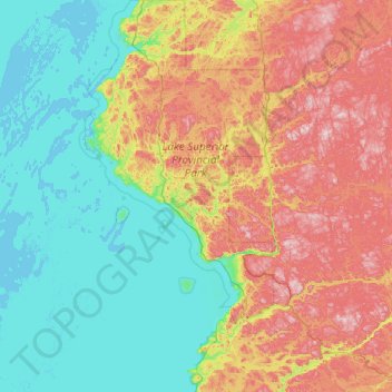
Name: Topografische Karte Lake Superior Provincial Park, Höhe, Relief.
Durchschnittliche Höhe: 320 m
Minimale Höhe: 176 m
Maximale Höhe: 631 m
Andere topografische Karten
Klicken Sie auf eine Karte, um ihre Topografie, ihre Höhe und ihr Relief anzuzeigen.
Vert Lake
Canada > Ontario > Algoma District
Vert Lake, Algoma District, Northeastern Ontario, Ontario, Canada
Durchschnittliche Höhe: 476 m
Manitowik Lake
Canada > Ontario > Algoma District
Manitowik Lake, Algoma District, Northeastern Ontario, Ontario, Canada
Durchschnittliche Höhe: 394 m
Cook Island
Canada > Ontario > Algoma District > The North Shore Township
Cook Island, The North Shore Township, Algoma District, Northeastern Ontario, Ontario, Canada
Durchschnittliche Höhe: 177 m