Geolokalisieren

Topografische Karte Black Force

Interaktive Karte

Klicken Sie auf die Karte, um die Höhe anzuzeigen.

Über diese Karte

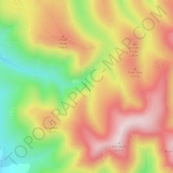
Name: Topografische Karte Black Force, Höhe, Relief.

Ort: Black Force, South Lakeland, Westmorland and Furness, England, LA8 0BT, United Kingdom (54.38663 -2.54972 54.38673 -2.54962)

Durchschnittliche Höhe: 437 m

Minimale Höhe: 190 m

Maximale Höhe: 641 m

Andere topografische Karten

Klicken Sie auf eine Karte, um ihre Topografie, ihre Höhe und ihr Relief anzuzeigen.

Scout Scar

United Kingdom > England > Westmorland and Furness > South Lakeland > Brigsteer

Scout Scar, Underbarrow and Bradleyfield, Brigsteer, South Lakeland, Westmorland and Furness, England, LA8 8BJ, United Kingdom

Durchschnittliche Höhe: 130 m

Pool Bank

United Kingdom > England > Westmorland and Furness > South Lakeland

Pool Bank, Crosthwaite and Lyth, South Lakeland, Westmorland and Furness, England, LA11 6SB, United Kingdom

Durchschnittliche Höhe: 80 m

Roudsea Wood

United Kingdom > England > Westmorland and Furness > South Lakeland > Haverthwaite

Roudsea Wood, Haverthwaite, South Lakeland, Westmorland and Furness, England, United Kingdom

Durchschnittliche Höhe: 7 m

Leece

United Kingdom > England > Westmorland and Furness > South Lakeland

Leece, South Lakeland, Westmorland and Furness, England, LA12 0QS, United Kingdom

Durchschnittliche Höhe: 25 m

Deepdale Beck

United Kingdom > England > Westmorland and Furness > South Lakeland > Dent

Deepdale Beck, Dent, South Lakeland, Westmorland and Furness, England, United Kingdom

Durchschnittliche Höhe: 280 m