
Topografische Karte Leyte
Interaktive Karte
Klicken Sie auf die Karte, um die Höhe anzuzeigen.
Über diese Karte
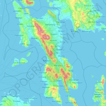
Name: Topografische Karte Leyte, Höhe, Relief.
Ort: Leyte, Eastern Visayas, Philippines (10.00448 124.28589 11.56351 125.26800)
Durchschnittliche Höhe: 68 m
Minimale Höhe: -1 m
Maximale Höhe: 1.238 m
Mahagnao Volcano Natural Park Located in Burauen, Leyte, about 66 km (41 mi) from Tacloban City, the Mahagnao Volcano Natural Park attracts visitors with its lakes, craters, hot springs, multi-colored mud, virgin forests and lagoon. It was proclaimed as a national park in 1937. Like other regions in the Philippines, the area enjoys a temperate climate. It has an elevation of 1,200 meters above sea level and an area of 635 hectares, within the boundaries of Burauen, La Paz and McArthur towns.
Andere topografische Karten
Klicken Sie auf eine Karte, um ihre Topografie, ihre Höhe und ihr Relief anzuzeigen.
Cuta
Philippines > Leyte > Barugo
Cuta, Barugo, 2nd District, Leyte, Eastern Visayas, 6519, Philippines
Durchschnittliche Höhe: 7 m
Mount Magsanga
Philippines > Leyte > Merida
Mount Magsanga, Merida, 4th District, Leyte, Eastern Visayas, 6540, Philippines
Durchschnittliche Höhe: 286 m
Green Valley
Philippines > Leyte > Ormoc
Green Valley, Ormoc, 4th District, Leyte, Eastern Visayas, 6541, Philippines
Durchschnittliche Höhe: 81 m
Patag
Philippines > Leyte > Baybay
Patag, Baybay, 5th District, Leyte, Eastern Visayas, 6521, Philippines
Durchschnittliche Höhe: 64 m
Paglaum
Philippines > Leyte > Carigara
Paglaum, Carigara, Leyte 2nd District, Leyte, Eastern Visayas, 6529, Philippines
Durchschnittliche Höhe: 276 m
Matag-Ob
Matag-Ob, Leyte 4th District, Leyte, Eastern Visayas, 6532, Philippines
Durchschnittliche Höhe: 66 m
Paglocsoon
Philippines > Leyte > Ormoc > Dolores
Paglocsoon, Dolores, Ormoc, Leyte 4th District, Leyte, Eastern Visayas, 6541, Philippines
Durchschnittliche Höhe: 322 m
Barugo
Barugo, Leyte 2nd District, Leyte, Eastern Visayas, 6519, Philippines
Durchschnittliche Höhe: 12 m
Hilongos
Hilongos, Leyte 5th District, Leyte, Eastern Visayas, 6524, Philippines
Durchschnittliche Höhe: 113 m
Imelda
Philippines > Leyte > Hilongos
Imelda, Hilongos, Leyte 5th District, Leyte, Eastern Visayas, 6524, Philippines
Durchschnittliche Höhe: 49 m
Palompon
Palompon, Leyte 4th District, Leyte, Eastern Visayas, 6538, Philippines
Durchschnittliche Höhe: 31 m
Sto. Nino
Philippines > Leyte > Mahaplag
Sto. Nino, Mahaplag, Leyte 5th District, Leyte, Eastern Visayas, 6512, Philippines
Durchschnittliche Höhe: 174 m
Cabacungan
Philippines > Leyte > Dulag
Cabacungan, Dulag, Leyte 2nd District, Leyte, Eastern Visayas, 6505, Philippines
Durchschnittliche Höhe: 13 m
San Isidro
Philippines > Leyte > Jaro
San Isidro, Jaro, Leyte 2nd District, Leyte, Eastern Visayas, 6527, Philippines
Durchschnittliche Höhe: 57 m
Sea of Clouds
Philippines > Leyte > Baybay
Sea of Clouds, Abuyog-Baybay City South Road, Baybay, Leyte 5th District, Leyte, Eastern Visayas, 6521, Philippines
Durchschnittliche Höhe: 187 m
Matalom
Matalom, Leyte 5th District, Leyte, Eastern Visayas, 6526, Philippines
Durchschnittliche Höhe: 85 m
Inopacan
Inopacan, Leyte 5th District, Leyte, Eastern Visayas, 6522, Philippines
Durchschnittliche Höhe: 113 m
Uyawan
Philippines > Leyte > Carigara
Uyawan, Carigara, Leyte 2nd District, Leyte, Eastern Visayas, 6529, Philippines
Durchschnittliche Höhe: 11 m
Ormoc
Ormoc, Leyte 4th District, Leyte, Eastern Visayas, 6541, Philippines
Durchschnittliche Höhe: 210 m
Calubian
Philippines > Leyte > Calubian
Calubian, Leyte 3rd District, Leyte, Eastern Visayas, 6534, Philippines
Durchschnittliche Höhe: 148 m
Baybay
Baybay, Leyte 5th District, Leyte, Eastern Visayas, 6521, Philippines
Durchschnittliche Höhe: 157 m
Barangay 62
Philippines > Leyte > Tacloban > Barangay 62
Barangay 62, Tacloban, Leyte, Eastern Visayas, 6500, Philippines
Durchschnittliche Höhe: 12 m