
Topografische Karte Montenebro
Interaktive Karte
Klicken Sie auf die Karte, um die Höhe anzuzeigen.
Über diese Karte
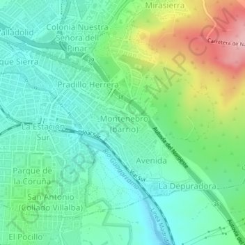
Name: Topografische Karte Montenebro, Höhe, Relief.
Durchschnittliche Höhe: 904 m
Minimale Höhe: 853 m
Maximale Höhe: 1.025 m
Andere topografische Karten
Klicken Sie auf eine Karte, um ihre Topografie, ihre Höhe und ihr Relief anzuzeigen.
Collado Villalba
España > Comunidad de Madrid > Collado Villalba
Polideportivo Dehesa Boyal, Collado Villalba, Cuenca del Guadarrama, Comunidad de Madrid, España
Durchschnittliche Höhe: 900 m
Collado Villalba
España > Comunidad de Madrid > Collado Villalba
Collado Villalba, Cuenca del Guadarrama, Comunidad de Madrid, España
Durchschnittliche Höhe: 903 m