
Spenden
Rüsten Sie sich für Ihr nächstes Abenteuer:
Als Amazon-Partner erhält diese Website eine Provision für qualifizierte Käufe, ohne zusätzliche Kosten für Sie.
Topografische Karte Radium Hot Springs
Klicken Sie auf die Karte, um die Höhe anzuzeigen.
Spenden
Rüsten Sie sich für Ihr nächstes Abenteuer:
Als Amazon-Partner erhält diese Website eine Provision für qualifizierte Käufe, ohne zusätzliche Kosten für Sie.
Über diese Karte
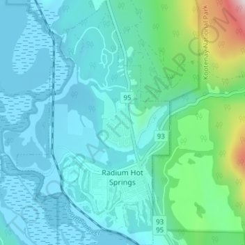
Name: Topografische Karte Radium Hot Springs, Höhe, Relief.
Durchschnittliche Höhe: 912 m
Minimale Höhe: 793 m
Maximale Höhe: 1.565 m
Spenden
Rüsten Sie sich für Ihr nächstes Abenteuer:
Als Amazon-Partner erhält diese Website eine Provision für qualifizierte Käufe, ohne zusätzliche Kosten für Sie.
Andere topografische Karten
Klicken Sie auf eine Karte, um ihre Topografie, ihre Höhe und ihr Relief anzuzeigen.
Fairmont Hot Springs
Canada > British Columbia > Regional District of East Kootenay > Area F (Columbia Lake/Windermere Lake)
Durchschnittliche Höhe: 920 m
Mount Worthington
Canada > British Columbia > Regional District of East Kootenay > Area F (Columbia Lake/Windermere Lake)
Durchschnittliche Höhe: 2.421 m
The Bugaboos
Canada > British Columbia > Regional District of East Kootenay > Area G (Forster Creek/Mount Assiniboine)
Durchschnittliche Höhe: 2.412 m
Jim Smith Lake
Canada > British Columbia > Regional District of East Kootenay > Area C (Moyie/Bull River)
Durchschnittliche Höhe: 1.091 m
Spenden
Rüsten Sie sich für Ihr nächstes Abenteuer:
Als Amazon-Partner erhält diese Website eine Provision für qualifizierte Käufe, ohne zusätzliche Kosten für Sie.
Moyie
Canada > British Columbia > Regional District of East Kootenay > Area C (Moyie/Bull River)
Durchschnittliche Höhe: 1.164 m
Mount Fernie
Canada > British Columbia > Regional District of East Kootenay > Area A (Upper Flathead/Elk Valley)
Durchschnittliche Höhe: 1.804 m
Grave Lake
Canada > British Columbia > Regional District of East Kootenay > Area A (Upper Flathead/Elk Valley)
Durchschnittliche Höhe: 1.426 m
Mount Farnham
Canada > British Columbia > Regional District of East Kootenay > Area G (Forster Creek/Mount Assiniboine)
Durchschnittliche Höhe: 2.791 m
Spenden
Rüsten Sie sich für Ihr nächstes Abenteuer:
Als Amazon-Partner erhält diese Website eine Provision für qualifizierte Käufe, ohne zusätzliche Kosten für Sie.
Mount Strachan
Canada > British Columbia > Regional District of East Kootenay > Area A (Upper Flathead/Elk Valley)
Durchschnittliche Höhe: 2.198 m
Wardner
Canada > British Columbia > Regional District of East Kootenay > Area C (Moyie/Bull River)
Durchschnittliche Höhe: 815 m
Kragmont
Canada > British Columbia > Regional District of East Kootenay > Area B (Lake Koocanusa)
Durchschnittliche Höhe: 788 m
Tent Mountain
Canada > British Columbia > Regional District of East Kootenay > Area A (Upper Flathead/Elk Valley)
Durchschnittliche Höhe: 1.873 m
Spenden
Rüsten Sie sich für Ihr nächstes Abenteuer:
Als Amazon-Partner erhält diese Website eine Provision für qualifizierte Käufe, ohne zusätzliche Kosten für Sie.
Rocky Mountains
Canada > British Columbia > Regional District of East Kootenay > Area A (Upper Flathead/Elk Valley)
Durchschnittliche Höhe: 2.159 m
Lazy Lake
Canada > British Columbia > Regional District of East Kootenay > Area E (Saint Mary/Skookumchuck)
Durchschnittliche Höhe: 1.080 m
Tumbling NE5
Canada > British Columbia > Regional District of East Kootenay > Area G (Forster Creek/Mount Assiniboine)
Durchschnittliche Höhe: 2.146 m
Monroe Lake
Canada > British Columbia > Regional District of East Kootenay > Area C (Moyie/Bull River)
Durchschnittliche Höhe: 1.105 m
Spenden
Rüsten Sie sich für Ihr nächstes Abenteuer:
Als Amazon-Partner erhält diese Website eine Provision für qualifizierte Käufe, ohne zusätzliche Kosten für Sie.
Grasmere
Canada > British Columbia > Regional District of East Kootenay > Area B (Lake Koocanusa)
Durchschnittliche Höhe: 1.067 m
Rocky Mountains
Canada > British Columbia > Regional District of East Kootenay > Area A (Upper Flathead/Elk Valley)
Durchschnittliche Höhe: 2.159 m
Elk River
Canada > British Columbia > Regional District of East Kootenay > Fernie
Durchschnittliche Höhe: 1.134 m
Panorama Mountain Village
Canada > British Columbia > Regional District of East Kootenay > Area F (Columbia Lake/Windermere Lake)
Durchschnittliche Höhe: 1.412 m
Spenden
Rüsten Sie sich für Ihr nächstes Abenteuer:
Als Amazon-Partner erhält diese Website eine Provision für qualifizierte Käufe, ohne zusätzliche Kosten für Sie.
Purcell Mountains
Canada > British Columbia > Regional District of East Kootenay > Area G (Forster Creek/Mount Assiniboine)
Durchschnittliche Höhe: 2.710 m
Mount Allen
Canada > British Columbia > Regional District of East Kootenay > Area G (Forster Creek/Mount Assiniboine)
Durchschnittliche Höhe: 2.674 m
Bull Mountain
Canada > British Columbia > Regional District of East Kootenay > Area C (Moyie/Bull River)
Durchschnittliche Höhe: 2.068 m
Spillimacheen
Canada > British Columbia > Regional District of East Kootenay > Area G (Forster Creek/Mount Assiniboine)
Durchschnittliche Höhe: 971 m
Spenden
Rüsten Sie sich für Ihr nächstes Abenteuer:
Als Amazon-Partner erhält diese Website eine Provision für qualifizierte Käufe, ohne zusätzliche Kosten für Sie.
The Nublet
Canada > British Columbia > Regional District of East Kootenay > Area G (Forster Creek/Mount Assiniboine)
Durchschnittliche Höhe: 2.301 m
Fording River
Canada > British Columbia > Regional District of East Kootenay > Elkford
Durchschnittliche Höhe: 1.787 m
Upper Elk Lake
Canada > British Columbia > Regional District of East Kootenay > Area A (Upper Flathead/Elk Valley)
Durchschnittliche Höhe: 1.982 m
Wasa Lake
Canada > British Columbia > Regional District of East Kootenay > Area E (Saint Mary/Skookumchuck) > Wasa
Durchschnittliche Höhe: 793 m
Spenden
Rüsten Sie sich für Ihr nächstes Abenteuer:
Als Amazon-Partner erhält diese Website eine Provision für qualifizierte Käufe, ohne zusätzliche Kosten für Sie.
Whiteswan Lake
Canada > British Columbia > Regional District of East Kootenay > Area F (Columbia Lake/Windermere Lake)
Durchschnittliche Höhe: 1.392 m
Kootenay National Park
Canada > British Columbia > Regional District of East Kootenay
Kootenay National Park is a national park located in southeastern British Columbia, Canada, and is one component of the Canadian Rocky Mountain Parks World Heritage Site. The park consists of 1,406 km2 (543 sq mi) of the Canadian Rockies, including parts of the Kootenay and Park mountain ranges, the Kootenay…
Durchschnittliche Höhe: 1.832 m
Valley of the Rocks
Canada > British Columbia > Regional District of East Kootenay > Area G (Forster Creek/Mount Assiniboine)
Durchschnittliche Höhe: 2.198 m
Baynes Lake
Canada > British Columbia > Regional District of East Kootenay > Area B (Lake Koocanusa)
Durchschnittliche Höhe: 796 m
Spenden
Rüsten Sie sich für Ihr nächstes Abenteuer:
Als Amazon-Partner erhält diese Website eine Provision für qualifizierte Käufe, ohne zusätzliche Kosten für Sie.
Gold Creek
Canada > British Columbia > Regional District of East Kootenay > Area B (Lake Koocanusa)
Durchschnittliche Höhe: 823 m
Barnes Lake
Canada > British Columbia > Regional District of East Kootenay > Area A (Upper Flathead/Elk Valley)
Durchschnittliche Höhe: 2.073 m
Mount Strachan
Canada > British Columbia > Regional District of East Kootenay > Area A (Upper Flathead/Elk Valley)
Durchschnittliche Höhe: 2.198 m
Wilmer
Canada > British Columbia > Regional District of East Kootenay > Area G (Forster Creek/Mount Assiniboine)
Durchschnittliche Höhe: 881 m
Spenden
Rüsten Sie sich für Ihr nächstes Abenteuer:
Als Amazon-Partner erhält diese Website eine Provision für qualifizierte Käufe, ohne zusätzliche Kosten für Sie.
Windermere
Canada > British Columbia > Regional District of East Kootenay > Area F (Columbia Lake/Windermere Lake)
Durchschnittliche Höhe: 842 m
Shuswap
Canada > British Columbia > Regional District of East Kootenay > Area F (Columbia Lake/Windermere Lake)
Durchschnittliche Höhe: 926 m
Fort Steele
Canada > British Columbia > Regional District of East Kootenay > Area C (Moyie/Bull River)
Durchschnittliche Höhe: 797 m
Grizzly Peak
Canada > British Columbia > Regional District of East Kootenay > Area A (Upper Flathead/Elk Valley)
Durchschnittliche Höhe: 1.962 m
Spenden
Rüsten Sie sich für Ihr nächstes Abenteuer:
Als Amazon-Partner erhält diese Website eine Provision für qualifizierte Käufe, ohne zusätzliche Kosten für Sie.
Findlay Creek
Canada > British Columbia > Regional District of East Kootenay > Area F (Columbia Lake/Windermere Lake)
Durchschnittliche Höhe: 1.270 m
Ta Ta Creek
Canada > British Columbia > Regional District of East Kootenay > Area E (Saint Mary/Skookumchuck)
Durchschnittliche Höhe: 854 m
Maiden Lake
Canada > British Columbia > Regional District of East Kootenay > Fernie
Durchschnittliche Höhe: 1.045 m
Big White Peak
Canada > British Columbia > Regional District of East Kootenay > Area B (Lake Koocanusa)
Durchschnittliche Höhe: 1.860 m
Spenden
Rüsten Sie sich für Ihr nächstes Abenteuer:
Als Amazon-Partner erhält diese Website eine Provision für qualifizierte Käufe, ohne zusätzliche Kosten für Sie.
Purcell Mountains
Canada > British Columbia > Regional District of East Kootenay > Area G (Forster Creek/Mount Assiniboine)
Durchschnittliche Höhe: 2.710 m
Mount Bisaro
Canada > British Columbia > Regional District of East Kootenay > Area C (Moyie/Bull River)
Durchschnittliche Höhe: 2.115 m
Baptiste Lake
Canada > British Columbia > Regional District of East Kootenay > Area G (Forster Creek/Mount Assiniboine)
Durchschnittliche Höhe: 1.067 m
Elko
Canada > British Columbia > Regional District of East Kootenay > Area B (Lake Koocanusa)
Durchschnittliche Höhe: 1.016 m
Spenden
Rüsten Sie sich für Ihr nächstes Abenteuer:
Als Amazon-Partner erhält diese Website eine Provision für qualifizierte Käufe, ohne zusätzliche Kosten für Sie.
Steeples
Canada > British Columbia > Regional District of East Kootenay > Cranbrook
Durchschnittliche Höhe: 940 m
Fernie
Canada > British Columbia > Regional District of East Kootenay > Fernie
Durchschnittliche Höhe: 1.551 m
Elkford
Canada > British Columbia > Regional District of East Kootenay > Elkford > Elkford
Durchschnittliche Höhe: 1.544 m
Morrissey Provincial Park
Canada > British Columbia > Regional District of East Kootenay > Area A (Upper Flathead/Elk Valley)
Durchschnittliche Höhe: 1.040 m
Spenden
Rüsten Sie sich für Ihr nächstes Abenteuer:
Als Amazon-Partner erhält diese Website eine Provision für qualifizierte Käufe, ohne zusätzliche Kosten für Sie.
Mount Erickson
Canada > British Columbia > Regional District of East Kootenay > Area A (Upper Flathead/Elk Valley)
Durchschnittliche Höhe: 1.938 m
Caribou Park
Canada > British Columbia > Regional District of East Kootenay > Elkford
Durchschnittliche Höhe: 1.323 m
Cobb Lake
Canada > British Columbia > Regional District of East Kootenay > Area G (Forster Creek/Mount Assiniboine)
Durchschnittliche Höhe: 1.366 m
Redding Creek
Canada > British Columbia > Regional District of East Kootenay > Area E (Saint Mary/Skookumchuck)
Durchschnittliche Höhe: 1.762 m
Spenden
Rüsten Sie sich für Ihr nächstes Abenteuer:
Als Amazon-Partner erhält diese Website eine Provision für qualifizierte Käufe, ohne zusätzliche Kosten für Sie.