
Topografische Karte Pont-Farcy
Interaktive Karte
Klicken Sie auf die Karte, um die Höhe anzuzeigen.
Über diese Karte
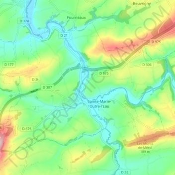
Name: Topografische Karte Pont-Farcy, Höhe, Relief.
Durchschnittliche Höhe: 108 m
Minimale Höhe: 39 m
Maximale Höhe: 244 m
Andere topografische Karten
Klicken Sie auf eine Karte, um ihre Topografie, ihre Höhe und ihr Relief anzuzeigen.
50420
France > Normandie > Manche > Tessy-Bocage
50420, Tessy-sur-Vire, Tessy-Bocage, Saint-Lô, Manche, Normandie, France métropolitaine, France
Durchschnittliche Höhe: 73 m
Les Hauts Vents
France > Normandie > Manche > Tessy-Bocage
Les Hauts Vents, Pont-Farcy, Tessy-Bocage, Saint-Lô, Manche, Normandie, France métropolitaine, 14380, France
Durchschnittliche Höhe: 104 m
Beau Costil
France > Normandie > Manche > Tessy-Bocage
Beau Costil, Pont-Farcy, Tessy-Bocage, Saint-Lô, Manche, Normandie, France métropolitaine, 14380, France
Durchschnittliche Höhe: 100 m
Tessy-sur-Vire
France > Normandie > Manche > Tessy-Bocage
Tessy-sur-Vire, Tessy-Bocage, Saint-Lô, Manche, Normandie, France métropolitaine, 50420, France
Durchschnittliche Höhe: 93 m
La Furetière
France > Normandie > Manche > Tessy-Bocage
La Furetière, Tessy-sur-Vire, Tessy-Bocage, Saint-Lô, Manche, Normandie, France métropolitaine, 50420, France
Durchschnittliche Höhe: 94 m
Le Moulin Sous Le Bois
France > Normandie > Manche > Tessy-Bocage > Le Moulin Sous Le Bois
Le Moulin Sous Le Bois, Pont-Farcy, Tessy-Bocage, Saint-Lô, Manche, Normandie, France métropolitaine, 14380, France
Durchschnittliche Höhe: 98 m
la campagne
France > Normandie > Manche > Tessy-Bocage > la campagne
la campagne, Tessy-sur-Vire, Tessy-Bocage, Saint-Lô, Manche, Normandie, France métropolitaine, 50420, France
Durchschnittliche Höhe: 74 m