
Topografische Karte King Peak
Interaktive Karte
Klicken Sie auf die Karte, um die Höhe anzuzeigen.
Über diese Karte
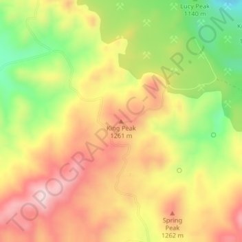
Name: Topografische Karte King Peak, Höhe, Relief.
Ort: King Peak, Yavapai County, Arizona, USA (34.56525 -113.23053 34.56535 -113.23043)
Durchschnittliche Höhe: 1.179 m
Minimale Höhe: 995 m
Maximale Höhe: 1.332 m
Andere topografische Karten
Klicken Sie auf eine Karte, um ihre Topografie, ihre Höhe und ihr Relief anzuzeigen.
Sevenmile Mountains
Sevenmile Mountains, Gila County, Arizona, USA
Durchschnittliche Höhe: 1.511 m
Castle Mountains
Castle Mountains, Pima County, Arizona, USA
Durchschnittliche Höhe: 741 m
Grand Canyon National Park
Grand Canyon National Park, Swamp Ridge Road, Coconino County, Arizona, USA
Durchschnittliche Höhe: 1.685 m
John the Baptist Mountains
John the Baptist Mountains, Pima County, Arizona, USA
Durchschnittliche Höhe: 523 m
Mount Lemmon
Mount Lemmon, Pima County, Arizona, 85619, USA
Durchschnittliche Höhe: 2.514 m
Tokyo Bay
USA > Arizona > Mohave Crossing
Tokyo Bay, Lost Cabin Wash, Mohave Crossing, Mohave County, Arizona, USA
Durchschnittliche Höhe: 221 m
Organ Pipe Cactus National Monument
Organ Pipe Cactus National Monument, Dripping Springs Trail, Pima County, Arizona, USA
Durchschnittliche Höhe: 494 m
Laguna Mountains
Laguna Mountains, Yuma, Yuma County, Arizona, USA
Durchschnittliche Höhe: 141 m
Granite Mountains
Granite Mountains, Pima County, Arizona, USA
Durchschnittliche Höhe: 394 m