Geolokalisieren

Topografische Karte Neemuch

Klicken Sie auf die Karte, um die Höhe anzuzeigen.

Über diese Karte

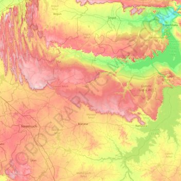
Name: Topografische Karte Neemuch, Höhe, Relief.

Ort: Neemuch, Madhya Pradesh, India (24.21028 74.70861 25.04850 75.60800)

Durchschnittliche Höhe: 452 m

Minimale Höhe: 298 m

Maximale Höhe: 609 m

Andere topografische Karten

Klicken Sie auf eine Karte, um ihre Topografie, ihre Höhe und ihr Relief anzuzeigen.

Bhopal

India > Madhya Pradesh > Huzur Tahsil

Bhopal has an average elevation of 500 metres (1401 ft) and is located in the central part of India, just north of the upper limit of the Vindhya mountain ranges. Located on the Malwa plateau, it is higher than the north Indian plains and the land rises towards the Vindhya Range to the south. The city has…

Durchschnittliche Höhe: 498 m

Indore

India > Madhya Pradesh > Juni Indore Tahsil

Indore /ɪnˈdɔːr/ (listen) is the most populous and the largest city in the Indian state of Madhya Pradesh. It serves as the headquarters of both Indore District and Indore Division. It is also considered as an education hub of the state and has campuses of both the Indian Institute of Technology and the…

Durchschnittliche Höhe: 555 m

Gadheri

India > Madhya Pradesh > Ranjhi Tahsil

Durchschnittliche Höhe: 472 m

Khandwa

India > Madhya Pradesh > Khandwa Nagar Tahsil

Khandwa is located at 21°50′N 76°20′E / 21.83°N 76.33°E / 21.83; 76.33. It has an average elevation of 313 metres (1026 feet).

Durchschnittliche Höhe: 325 m

Vielen Dank für die Unterstützung dieser Website ❤️
Spenden

Rüsten Sie sich für Ihr nächstes Abenteuer:

Als Amazon-Partner erhält diese Website eine Provision für qualifizierte Käufe, ohne zusätzliche Kosten für Sie.

Ujjain

India > Madhya Pradesh > Ujjain NagarTahsil

Ujjain is located in the west-central part of India, and is north of the upper limit of the Vindhya mountain ranges. Located on the Malwa plateau, it is higher than the north Indian plains and the land rises towards the Vindhya Range to the south. Ujjain's co-ordinates are 23°10′N 75°46′E /…

Durchschnittliche Höhe: 501 m

Gwalior

India > Madhya Pradesh > Gird Tahsil

Gwalior is located at 26°13′N 78°11′E / 26.22°N 78.18°E / 26.22; 78.18. in northern Madhya Pradesh 300 km (186 miles) from Delhi. It has an average elevation of 197 metres (646 feet). Most part of it comes under the Bundelkhand area.

Durchschnittliche Höhe: 235 m

Dighawani

India > Madhya Pradesh > Parasia Tahsil

Durchschnittliche Höhe: 754 m

Bhadesar

India > Madhya Pradesh > Nowgong Tahsil

Durchschnittliche Höhe: 256 m

Pandli

India > Madhya Pradesh > Sheopur Tahsil

Durchschnittliche Höhe: 214 m

Chanderi

India > Madhya Pradesh > Chanderi Tahsil

Chanderi is located at 24°43′N 78°08′E / 24.72°N 78.13°E / 24.72; 78.13. It has an average elevation of 456 metres (1496 feet).

Durchschnittliche Höhe: 440 m

Gadha

India > Madhya Pradesh > Rajnagar Tahsil

Durchschnittliche Höhe: 246 m

Dr. Ambedkar Nagar

India > Madhya Pradesh > Mhow Tahsil

Durchschnittliche Höhe: 581 m

Vielen Dank für die Unterstützung dieser Website ❤️
Spenden

Rüsten Sie sich für Ihr nächstes Abenteuer:

Als Amazon-Partner erhält diese Website eine Provision für qualifizierte Käufe, ohne zusätzliche Kosten für Sie.

Kondh

India > Madhya Pradesh > Ron Tahsil

Durchschnittliche Höhe: 132 m

Bilaiki

India > Madhya Pradesh > Kesli Tahsil > Jhiria

Durchschnittliche Höhe: 543 m

Bina Etawa

India > Madhya Pradesh > Bina Tahsil

Durchschnittliche Höhe: 416 m

Union Carbide

India > Madhya Pradesh > Huzur Tahsil > Bhopal

Durchschnittliche Höhe: 497 m

Keoti

India > Madhya Pradesh > Sirmour Tahsil

Durchschnittliche Höhe: 290 m

Suwalal

India > Madhya Pradesh > Morena Nagar Tahsil > Gothiapura

Durchschnittliche Höhe: 175 m

Umaria Pan

India > Madhya Pradesh > Dhimarkheda Tahsil

Durchschnittliche Höhe: 400 m

Barda Barkheda

India > Madhya Pradesh > Badod Tahsil

Durchschnittliche Höhe: 475 m

Vielen Dank für die Unterstützung dieser Website ❤️
Spenden

Rüsten Sie sich für Ihr nächstes Abenteuer:

Als Amazon-Partner erhält diese Website eine Provision für qualifizierte Käufe, ohne zusätzliche Kosten für Sie.

Kudawa

India > Madhya Pradesh > Maihar Tahsil

Durchschnittliche Höhe: 366 m

Bisakhedi

India > Madhya Pradesh > Ghatiya Tahsil > Bamori

Durchschnittliche Höhe: 510 m

Sonkatch

India > Madhya Pradesh > Narsinghgarh Tahsil

Durchschnittliche Höhe: 448 m

Manpur

India > Madhya Pradesh > Mhow Tahsil

Manpur is located at 22°26′N 75°37′E / 22.43°N 75.62°E / 22.43; 75.62. It has an average elevation of 567 metres (1860 feet).

Durchschnittliche Höhe: 574 m

Vielen Dank für die Unterstützung dieser Website ❤️
Spenden

Rüsten Sie sich für Ihr nächstes Abenteuer:

Als Amazon-Partner erhält diese Website eine Provision für qualifizierte Käufe, ohne zusätzliche Kosten für Sie.

Kolua

India > Madhya Pradesh > Shamshabad Tahsil

Durchschnittliche Höhe: 498 m

Bisonia

India > Madhya Pradesh > Shamshabad Tahsil

Durchschnittliche Höhe: 484 m

Indore

India > Madhya Pradesh > Juni Indore Tahsil

Durchschnittliche Höhe: 555 m

Jirapur

India > Madhya Pradesh > Jirapur Tahsil

Jirapur Tehsil is bounded by Khilchipur Tehsil towards east, Nalkheda Tehsil towards south, Susner Tehsil towards west, Bakani Tehsil towards the north. Sarangpur City, Shajapur City, Pachore City, Jhalawar City are the nearby Cities to Jirapur. This city is near on MP and Rajasthan border. Jirapur consists of…

Durchschnittliche Höhe: 396 m

Vielen Dank für die Unterstützung dieser Website ❤️
Spenden

Rüsten Sie sich für Ihr nächstes Abenteuer:

Als Amazon-Partner erhält diese Website eine Provision für qualifizierte Käufe, ohne zusätzliche Kosten für Sie.

Muhara

India > Madhya Pradesh > Raipura Tahsil

Durchschnittliche Höhe: 316 m

Maheshwar

India > Madhya Pradesh > Maheshwar Tahsil

Durchschnittliche Höhe: 166 m

Narmadapuram

India > Madhya Pradesh > Narmadapuram Tahsil

Durchschnittliche Höhe: 344 m

Rajendranagar

India > Madhya Pradesh > Mohangarh Tahsil

Durchschnittliche Höhe: 320 m

Bhina

India > Madhya Pradesh > Ajaigarh Tahsil

Durchschnittliche Höhe: 141 m

Ujjain

India > Madhya Pradesh > Ujjain NagarTahsil

Ujjain is located in the west-central part of India, and is north of the upper limit of the Vindhya mountain ranges. Located on the Malwa plateau, it is higher than the north Indian plains and the land rises towards the Vindhya Range to the south. Ujjain's coordinates are 23°10′N 75°46′E /…

Durchschnittliche Höhe: 501 m

Barja

India > Madhya Pradesh > Rehatgarh Tahsil

Durchschnittliche Höhe: 310 m

Dewas

India > Madhya Pradesh > Dewas Nagar Tahsil

Durchschnittliche Höhe: 528 m

Ditalwada

India > Madhya Pradesh > Raghogarh Tahsil

Durchschnittliche Höhe: 404 m

Barkhadi

India > Madhya Pradesh > Narwar Tahsil

Durchschnittliche Höhe: 315 m

Nagda

India > Madhya Pradesh > Nagda Tahsil

Durchschnittliche Höhe: 484 m

Tamia

India > Madhya Pradesh > Tamia Tahsil

Durchschnittliche Höhe: 935 m

Khajuraho

India > Madhya Pradesh > Rajnagar Tahsil

Durchschnittliche Höhe: 214 m

Bar Khera

India > Madhya Pradesh > Badod Tahsil

Durchschnittliche Höhe: 482 m

Hatiyakheda

India > Madhya Pradesh > Gulabganj Tahsil

Durchschnittliche Höhe: 425 m

Badjhiri

India > Madhya Pradesh > Huzur Tahsil

Durchschnittliche Höhe: 540 m

Jivapur Mahodia

India > Madhya Pradesh > Jawar Tahsil

Durchschnittliche Höhe: 487 m

Khandwa

India > Madhya Pradesh > Khandwa Nagar Tahsil

Khandwa is located at 21°50′N 76°20′E / 21.83°N 76.33°E / 21.83; 76.33. It has an average elevation of 313 metres (1026 feet).

Durchschnittliche Höhe: 325 m

Indore

India > Madhya Pradesh > Juni Indore Tahsil

Durchschnittliche Höhe: 555 m

Ratona

India > Madhya Pradesh > Sagar Nagar Tahsil

Durchschnittliche Höhe: 521 m

Vielen Dank für die Unterstützung dieser Website ❤️
Spenden

Narsinghgarh

India > Madhya Pradesh > Narsinghgarh Tahsil

Durchschnittliche Höhe: 472 m

Orchha

India > Madhya Pradesh > Orchha Tahsil

Durchschnittliche Höhe: 227 m

Pinda

India > Madhya Pradesh > Mandsaur Tahsil

Durchschnittliche Höhe: 457 m

Badagaon No2

India > Madhya Pradesh > Murar Tahsil

Durchschnittliche Höhe: 203 m

Sindhora

India > Madhya Pradesh > Berasia Tahsil

Durchschnittliche Höhe: 446 m

Bijanwada

India > Madhya Pradesh > Pipariya Tahsil

Durchschnittliche Höhe: 342 m

Saujana

India > Madhya Pradesh > Bhander Tahsil

Durchschnittliche Höhe: 165 m

Morena

India > Madhya Pradesh

Durchschnittliche Höhe: 273 m

Chak Islampur

India > Madhya Pradesh > Dabra Tahsil > Chak Braipur

Durchschnittliche Höhe: 212 m

Indawar

India > Madhya Pradesh > Manpur Tahsil

Durchschnittliche Höhe: 351 m

Seoni

India > Madhya Pradesh > Seoni Tahsil

Durchschnittliche Höhe: 593 m

Bijna

India > Madhya Pradesh > Lakhnadon Tahsil > Ganeshganj Chhota

Durchschnittliche Höhe: 583 m

Vielen Dank für die Unterstützung dieser Website ❤️
Spenden

Khandwa

India > Madhya Pradesh > Khandwa Nagar Tahsil

Khandwa is located at 21°50′N 76°20′E / 21.83°N 76.33°E / 21.83; 76.33. It has an average elevation of 313 metres (1026 feet).

Durchschnittliche Höhe: 325 m

Ujjain

India > Madhya Pradesh > Ujjain NagarTahsil

Ujjain is located in the west-central part of India, and is north of the upper limit of the Vindhya mountain ranges. Located on the Malwa plateau, it is higher than the north Indian plains and the land rises towards the Vindhya Range to the south. Ujjain's coordinates are 23°10′N 75°46′E /…

Durchschnittliche Höhe: 501 m

Dr. Ambedkar Nagar

India > Madhya Pradesh > Mhow Tahsil

Durchschnittliche Höhe: 581 m

Prabhatpattan

India > Madhya Pradesh > Prabhatpattan Tahsil

Durchschnittliche Höhe: 691 m

Vielen Dank für die Unterstützung dieser Website ❤️
Spenden

Rüsten Sie sich für Ihr nächstes Abenteuer:

Als Amazon-Partner erhält diese Website eine Provision für qualifizierte Käufe, ohne zusätzliche Kosten für Sie.

Sindhora

India > Madhya Pradesh > Berasia Tahsil

Durchschnittliche Höhe: 446 m

ganga river

India > Madhya Pradesh > Juni Indore Tahsil > Indore

Durchschnittliche Höhe: 556 m

Mamon

India > Madhya Pradesh > Tikamgarh Tahsil

Durchschnittliche Höhe: 342 m

Nagda

India > Madhya Pradesh > Nagda Tahsil

Durchschnittliche Höhe: 484 m

Vielen Dank für die Unterstützung dieser Website ❤️
Spenden

Rüsten Sie sich für Ihr nächstes Abenteuer:

Als Amazon-Partner erhält diese Website eine Provision für qualifizierte Käufe, ohne zusätzliche Kosten für Sie.

Kashmiri

India > Madhya Pradesh > Baihar Tahsil

Durchschnittliche Höhe: 635 m

Pachmarhi

India > Madhya Pradesh > Pipariya Tahsil

Pachmarhi has an altitude of 1,067 meters above sea level. Dhupgarh, the highest point (1,352 meters) in Madhya Pradesh and the Satpura range, is located nearby. The town is wholly located within the Pachmarhi Biosphere Reserve and the Satpura Tiger Reserve.

Durchschnittliche Höhe: 968 m

Deora

India > Madhya Pradesh > Joura Tahsil

Durchschnittliche Höhe: 372 m

Kundibeh

India > Madhya Pradesh > Khilchipur Tahsil

Durchschnittliche Höhe: 427 m

Vielen Dank für die Unterstützung dieser Website ❤️
Spenden

Khajuraho

India > Madhya Pradesh > Rajnagar Tahsil

Durchschnittliche Höhe: 214 m

Mandhata

India > Madhya Pradesh > Punasa Tahsil > Omkareshwar

Durchschnittliche Höhe: 206 m

Nagda

India > Madhya Pradesh > Nagda Tahsil

Durchschnittliche Höhe: 484 m

Malhara

India > Madhya Pradesh > Prabhatpattan Tahsil

Durchschnittliche Höhe: 728 m

Vielen Dank für die Unterstützung dieser Website ❤️
Spenden

Rüsten Sie sich für Ihr nächstes Abenteuer:

Als Amazon-Partner erhält diese Website eine Provision für qualifizierte Käufe, ohne zusätzliche Kosten für Sie.

Indore

India > Madhya Pradesh

Durchschnittliche Höhe: 429 m

Dr. Ambedkar Nagar

India > Madhya Pradesh > Mhow Tahsil

Durchschnittliche Höhe: 581 m

Bamhrauli

India > Madhya Pradesh > Bamor Tahsil

Durchschnittliche Höhe: 166 m

Sagar

India > Madhya Pradesh > Sagar Nagar Tahsil

Sagar has an average elevation of 427 metres (1401 ft) and is located in the central part of India, just north of the upper limit of the Vindhya mountain ranges.here is a lake in middle of the city.

Durchschnittliche Höhe: 515 m

Vielen Dank für die Unterstützung dieser Website ❤️
Spenden

Rüsten Sie sich für Ihr nächstes Abenteuer:

Als Amazon-Partner erhält diese Website eine Provision für qualifizierte Käufe, ohne zusätzliche Kosten für Sie.

Maihar

India > Madhya Pradesh > Maihar Tahsil

Durchschnittliche Höhe: 356 m

Bhopal

India > Madhya Pradesh > Huzur Tahsil

Bhopal has an average elevation of 500 metres (1401 ft) and is located in the central part of India, just north of the upper limit of the Vindhya mountain ranges. Located on the Malwa plateau, it is higher than the north Indian plains and the land rises towards the Vindhya Range to the south. The city has…

Durchschnittliche Höhe: 498 m

Bijuri

India > Madhya Pradesh > Kotma Tehsil

Durchschnittliche Höhe: 557 m

Pakhari

India > Madhya Pradesh > Narsinghgarh Tahsil

Durchschnittliche Höhe: 454 m

Bhopal

India > Madhya Pradesh > Huzur Tahsil

Bhopal has an average elevation of 500 metres (1401 ft) and is located in the central part of India, just north of the upper limit of the Vindhya mountain ranges. Located on the Malwa plateau, it is higher than the north Indian plains and the land rises towards the Vindhya Range to the south. The city has…

Durchschnittliche Höhe: 498 m

Katangi

India > Madhya Pradesh > Katangi Tahsil

Durchschnittliche Höhe: 346 m

Yeshwant Club

India > Madhya Pradesh > Juni Indore Tahsil > Indore

Durchschnittliche Höhe: 555 m

Ashoknagar

India > Madhya Pradesh > Ashoknagar Tahsil

Durchschnittliche Höhe: 495 m

Vielen Dank für die Unterstützung dieser Website ❤️
Spenden

Buxwaha

India > Madhya Pradesh > Buxwaha Tahsil

Durchschnittliche Höhe: 490 m

Mohra

India > Madhya Pradesh > Pohri Tahsil

Durchschnittliche Höhe: 286 m

Amlay

India > Madhya Pradesh > Shujalpur Tahsil

Durchschnittliche Höhe: 467 m

Bargi Dam

India > Madhya Pradesh > Jabalpur Tahsil > Khapa

Durchschnittliche Höhe: 408 m

Rampara

India > Madhya Pradesh > Sailana Tahsil > Deogarh

Durchschnittliche Höhe: 503 m

Rajendranagar

India > Madhya Pradesh > Agar Tahsil

Durchschnittliche Höhe: 469 m

Indore

India > Madhya Pradesh > Juni Indore Tahsil

Durchschnittliche Höhe: 555 m

kaliasot dam

India > Madhya Pradesh > Huzur Tahsil > Bhopal

Durchschnittliche Höhe: 500 m

Lakhmipur

India > Madhya Pradesh > Ashta Tahsil

Durchschnittliche Höhe: 484 m

Saraswati

India > Madhya Pradesh > Juni Indore Tahsil

Durchschnittliche Höhe: 564 m

Ratlam

India > Madhya Pradesh > Ratlam Nagar Tahsil

Durchschnittliche Höhe: 485 m

Hoshangābād

India > Madhya Pradesh

Durchschnittliche Höhe: 439 m

Rüsten Sie sich für Ihr nächstes Abenteuer:

🕶️Gletscherbrillen - Maximaler UV-Schutz für Augen in großen Höhen
🧦Merino-Wandersocken - Blasenfreie Wanderungen durch beste Materialeigenschaften
🥾Wanderschuhe für Damen - Leichte und rutschfeste Wanderschuhe für schwieriges Gelände
📊Wanderkarten Set Deutschland - Komplettes Kartenset für Deutschland
🧹Camping Stühle - Bequeme Klappstühle für Outdoor

Als Amazon-Partner erhält diese Website eine Provision für qualifizierte Käufe, ohne zusätzliche Kosten für Sie.