
Topografische Karte Cerro Lobo
Interaktive Karte
Klicken Sie auf die Karte, um die Höhe anzuzeigen.
Über diese Karte
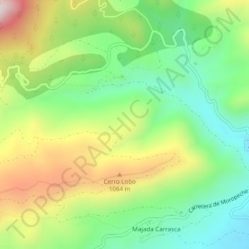
Name: Topografische Karte Cerro Lobo, Höhe, Relief.
Ort: Cerro Lobo, Yeste, Albacete, Castilla-La Mancha, España (38.41084 -2.36099 38.43084 -2.34099)
Durchschnittliche Höhe: 888 m
Minimale Höhe: 661 m
Maximale Höhe: 1.236 m
Andere topografische Karten
Klicken Sie auf eine Karte, um ihre Topografie, ihre Höhe und ihr Relief anzuzeigen.
Parque Natural de los Calares del Mundo y de la Sima
España > Castilla-La Mancha > Yeste
Parque Natural de los Calares del Mundo y de la Sima, AB-512, Los Ruscas, Tús, Yeste, Albacete, Castilla-La Mancha, 02485, España
Durchschnittliche Höhe: 1.125 m
Graya
España > Castilla-La Mancha > Yeste > Graya
Graya, Yeste, Albacete, Castilla-La Mancha, España
Durchschnittliche Höhe: 932 m
Los Argüellos
España > Castilla-La Mancha > Yeste
Los Argüellos, Yeste, Albacete, Castilla-La Mancha, España
Durchschnittliche Höhe: 671 m