
Topografische Karte Garanhuns
Interaktive Karte
Klicken Sie auf die Karte, um die Höhe anzuzeigen.
Über diese Karte
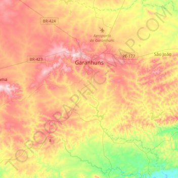
Name: Topografische Karte Garanhuns, Höhe, Relief.
Durchschnittliche Höhe: 738 m
Minimale Höhe: 445 m
Maximale Höhe: 1.018 m
Garanhuns is a city in the Brazilian state of Pernambuco. Located in the Borborema Plateau, the town is known as the "Suíça Pernambucana" (Pernambucan Switzerland) due to its elevation and relatively cool climate. It is also known as "Cidade das Flores" ("City of Flowers") or "Cidade da Garoa" ("City of Drizzle").