
Topografische Karte Chantemerle
Interaktive Karte
Klicken Sie auf die Karte, um die Höhe anzuzeigen.
Über diese Karte
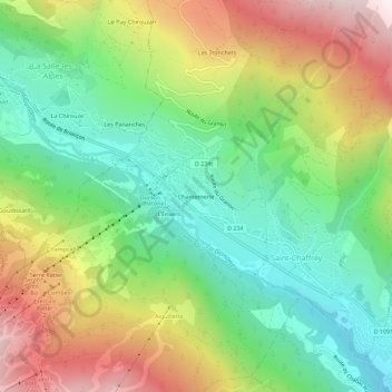
Name: Topografische Karte Chantemerle, Höhe, Relief.
Durchschnittliche Höhe: 1.638 m
Minimale Höhe: 1.259 m
Maximale Höhe: 2.214 m
Ce village est situé à 1 350 m d'altitude.
Andere topografische Karten
Klicken Sie auf eine Karte, um ihre Topografie, ihre Höhe und ihr Relief anzuzeigen.
Les Tronchets
France > Provence-Alpes-Côte d'Azur > Hautes-Alpes > Saint-Chaffrey
Les Tronchets, Saint-Chaffrey, Briançon, Hautes-Alpes, Provence-Alpes-Côte d'Azur, France métropolitaine, 05330, France
Durchschnittliche Höhe: 1.845 m
Col de Granon
France > Provence-Alpes-Côte d'Azur > Hautes-Alpes > Saint-Chaffrey
Col de Granon, Saint-Chaffrey, Briançon, Hautes-Alpes, Provence-Alpes-Côte d'Azur, France métropolitaine, 05330, France
Durchschnittliche Höhe: 2.291 m
L'Envers
France > Provence-Alpes-Côte d'Azur > Hautes-Alpes > Saint-Chaffrey
L'Envers, Saint-Chaffrey, Briançon, Hautes-Alpes, Provence-Alpes-Côte d'Azur, France métropolitaine, 05330, France
Durchschnittliche Höhe: 1.646 m
Via ferrata Rocher blanc facile
France > Provence-Alpes-Côte d'Azur > Hautes-Alpes > Saint-Chaffrey
Via ferrata Rocher blanc facile, La Ricelle, Saint-Chaffrey, Briançon, Hautes-Alpes, Provence-Alpes-Côte d'Azur, France métropolitaine, 05330, France
Durchschnittliche Höhe: 2.211 m