
Spenden
Rüsten Sie sich für Ihr nächstes Abenteuer:
Als Amazon-Partner erhält diese Website eine Provision für qualifizierte Käufe, ohne zusätzliche Kosten für Sie.
Topografische Karte Pune
Klicken Sie auf die Karte, um die Höhe anzuzeigen.
Spenden
Rüsten Sie sich für Ihr nächstes Abenteuer:
Als Amazon-Partner erhält diese Website eine Provision für qualifizierte Käufe, ohne zusätzliche Kosten für Sie.
Pune
Pune is situated at approximately 18° 32" north latitude and 73° 51" east longitude. The area of Pune district is 15,642 km2, and the municipal corporation area covers 518 km2. By road Pune is 149 km (93 mi) south-east of Mumbai, 580 km (360 mi) south-west of Indore, 695 km (432 mi) west of Nagpur, 1,173 km (729 mi) south of Delhi, 734 km (456 mi) north of Bangalore, 562 km (349 mi) north-west of Hyderabad. Pune lies on the western margin of the Deccan Plateau, at an altitude of 560 m (1,840 ft) above sea level. It is on the leeward side of the Sahyadri mountain range, which forms a barrier from the Arabian Sea. It is a hilly city, with Vetal Hill rising to 800 m (2,600 ft) above sea level. The Sinhagad fort is at an altitude of 1,300 metres (4,300 feet).
Spenden
Rüsten Sie sich für Ihr nächstes Abenteuer:
Als Amazon-Partner erhält diese Website eine Provision für qualifizierte Käufe, ohne zusätzliche Kosten für Sie.
Über diese Karte
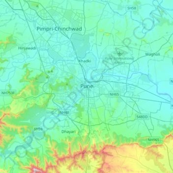
Name: Topografische Karte Pune, Höhe, Relief.
Durchschnittliche Höhe: 641 m
Minimale Höhe: 526 m
Maximale Höhe: 1.304 m
Spenden
Rüsten Sie sich für Ihr nächstes Abenteuer:
Als Amazon-Partner erhält diese Website eine Provision für qualifizierte Käufe, ohne zusätzliche Kosten für Sie.