
Topografische Karte Derby
Interaktive Karte
Klicken Sie auf die Karte, um die Höhe anzuzeigen.
Über diese Karte
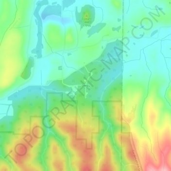
Name: Topografische Karte Derby, Höhe, Relief.
Ort: Derby, Saline County, Illinois, 62947, United States (37.60894 -88.40560 37.64894 -88.36560)
Durchschnittliche Höhe: 155 m
Minimale Höhe: 107 m
Maximale Höhe: 243 m
Andere topografische Karten
Klicken Sie auf eine Karte, um ihre Topografie, ihre Höhe und ihr Relief anzuzeigen.
Cornerville
United States > Illinois > Saline County
Cornerville, Saline County, Illinois, United States
Durchschnittliche Höhe: 142 m
Galatia
United States > Illinois > Saline County
Galatia, Saline County, Illinois, 62935, United States
Durchschnittliche Höhe: 129 m
Garden Of the Gods
United States > Illinois > Saline County
Garden Of the Gods, Saline County, Illinois, 62947, United States
Durchschnittliche Höhe: 194 m
Harrisburg
United States > Illinois > Saline County
Harrisburg, Saline County, Illinois, 62946, United States
Durchschnittliche Höhe: 115 m
Eldorado
United States > Illinois > Saline County
Eldorado, Saline County, Illinois, 62930, United States
Durchschnittliche Höhe: 125 m
Harrisburg
United States > Illinois > Saline County > Harrisburg
Harrisburg, Saline County, Illinois, 62946:62959, United States
Durchschnittliche Höhe: 115 m