
Topografische Karte Lituya Bay
Interaktive Karte
Klicken Sie auf die Karte, um die Höhe anzuzeigen.
Über diese Karte
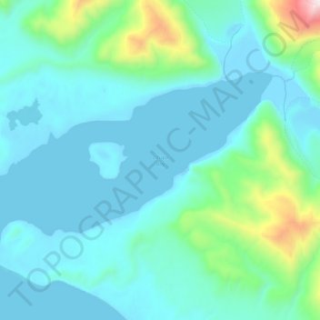
Name: Topografische Karte Lituya Bay, Höhe, Relief.
Ort: Lituya Bay, Unorganized Borough, Alaska, United States (58.61141 -137.67592 58.66618 -137.48479)
Durchschnittliche Höhe: 217 m
Minimale Höhe: -11 m
Maximale Höhe: 1.593 m
The same topography that leads to the heavy tidal currents also created the tsunami with the highest runup against a hillside in recorded history. On the night of July 9, 1958, an earthquake caused a landslide in the Gilbert Inlet at the head of the bay, generating a massive megatsunami which had sufficient energy to run up the hill slope just opposite of the landslide to a height measuring 1,719 feet (524 m), taller than the Empire State Building. There were three fishing boats anchored near the entrance of Lituya Bay on the day the giant wave occurred. One boat (the Sunmore) was sunk by the wave and debris as it attempted to exit the bay, and the two people on board (a married couple, the Wagners) were killed. The second boat (the Badger) was carried across the la Chasseuse, spit into the ocean, hit by a floating log and sunk but not before its occupants (a married couple, the Swansons) in spite of injuries, managed to board a skiff ultimately to be rescued. The third boat, the Edrie, crewed by father and son the Ulriches, was anchored at the opposite side of the bay entrance. The father, Howard, turned the boat to face the wave, which picked her up, snapped her anchor chain, carried her above the trees but then washed her back into the bay with no major damage. William A. Swanson and Howard G. Ulrich provided accounts of what they observed. Based on Swanson's description of the length of time it took the wave to reach his boat after overtopping Cenotaph Island near the bay's entrance, the wave may have been traveling 120 mph (190 km/h). When it reached the open sea, however, it dissipated quickly. This incident was the first direct evidence and eyewitness report of the existence of megatsunamis.
Andere topografische Karten
Klicken Sie auf eine Karte, um ihre Topografie, ihre Höhe und ihr Relief anzuzeigen.
Nikolai
United States > Alaska > Unorganized Borough
Nikolai, Unorganized Borough, Alaska, 99691, United States
Durchschnittliche Höhe: 132 m
McCarthy
United States > Alaska > Unorganized Borough
McCarthy, Unorganized Borough, Alaska, United States
Durchschnittliche Höhe: 960 m
University Peak
United States > Alaska > Unorganized Borough
University Peak, Unorganized Borough, Alaska, United States
Durchschnittliche Höhe: 3.437 m
Lulu Island
United States > Alaska > Unorganized Borough
Lulu Island, Unorganized Borough, Alaska, United States
Durchschnittliche Höhe: 68 m
Eagle
United States > Alaska > Unorganized Borough
Eagle, Unorganized Borough, Alaska, United States
Durchschnittliche Höhe: 285 m
Togiak
United States > Alaska > Unorganized Borough
Togiak, Unorganized Borough, Alaska, 99678, United States
Durchschnittliche Höhe: 26 m
Isabel Pass
United States > Alaska > Unorganized Borough
Isabel Pass, Unorganized Borough, Alaska, United States
Durchschnittliche Höhe: 1.032 m
Tanana
United States > Alaska > Unorganized Borough
Tanana, Unorganized Borough, Alaska, 99777, United States
Durchschnittliche Höhe: 91 m
Dillingham
United States > Alaska > Unorganized Borough
Dillingham, Unorganized Borough, Alaska, United States
Durchschnittliche Höhe: 19 m
Smith Island
United States > Alaska > Unorganized Borough
Smith Island, Unorganized Borough, Alaska, United States
Durchschnittliche Höhe: 7 m
Aniak
United States > Alaska > Unorganized Borough
Aniak, Unorganized Borough, Alaska, United States
Durchschnittliche Höhe: 25 m
Brevig Mission
United States > Alaska > Unorganized Borough
Brevig Mission, Unorganized Borough, Alaska, 99785, United States
Durchschnittliche Höhe: 16 m
Saint Paul Island
United States > Alaska > Unorganized Borough > St. Paul
Saint Paul Island, St. Paul, Unorganized Borough, Alaska, 99660, United States
Durchschnittliche Höhe: 10 m
Annette Island
United States > Alaska > Unorganized Borough
Annette Island, Unorganized Borough, Alaska, 99926, United States
Durchschnittliche Höhe: 78 m
Wiseman
United States > Alaska > Unorganized Borough
Wiseman, Unorganized Borough, Alaska, United States
Durchschnittliche Höhe: 760 m
Cordova
United States > Alaska > Unorganized Borough
Cordova, Unorganized Borough, Alaska, 99574, United States
Durchschnittliche Höhe: 143 m
Catalina Island
United States > Alaska > Unorganized Borough
Catalina Island, Unorganized Borough, Alaska, United States
Durchschnittliche Höhe: 5 m
Gates of the Arctic Wilderness
United States > Alaska > Unorganized Borough
Gates of the Arctic Wilderness, Unorganized Borough, Alaska, United States
Durchschnittliche Höhe: 663 m
Chicken
United States > Alaska > Unorganized Borough
Chicken, Unorganized Borough, Alaska, 99732, United States
Durchschnittliche Höhe: 728 m
Whitefish Lake
United States > Alaska > Unorganized Borough
Whitefish Lake, Unorganized Borough, Alaska, United States
Durchschnittliche Höhe: 359 m
Crooked Creek
United States > Alaska > Unorganized Borough
Crooked Creek, Unorganized Borough, Alaska, 99575, United States
Durchschnittliche Höhe: 190 m
Dry Creek
United States > Alaska > Unorganized Borough
Dry Creek, Unorganized Borough, Alaska, United States
Durchschnittliche Höhe: 915 m
Stevens Village
United States > Alaska > Unorganized Borough
Stevens Village, Unorganized Borough, Alaska, United States
Durchschnittliche Höhe: 94 m
Fort Yukon
United States > Alaska > Unorganized Borough > Fort Yukon
Fort Yukon, Unorganized Borough, Alaska, United States
Durchschnittliche Höhe: 133 m
Arctic Village
United States > Alaska > Unorganized Borough
Arctic Village, Unorganized Borough, Alaska, United States
Durchschnittliche Höhe: 748 m
Rampart
United States > Alaska > Unorganized Borough
Rampart, Unorganized Borough, Alaska, United States
Durchschnittliche Höhe: 532 m
Mount Sanford
United States > Alaska > Unorganized Borough
Mount Sanford, Unorganized Borough, Alaska, United States
Durchschnittliche Höhe: 4.221 m
Snowden Mountain
United States > Alaska > Unorganized Borough
Snowden Mountain, Unorganized Borough, Alaska, United States
Durchschnittliche Höhe: 1.365 m
Pelican
United States > Alaska > Unorganized Borough
Pelican, Unorganized Borough, Alaska, 99832, United States
Durchschnittliche Höhe: 78 m
Negro
United States > Alaska > Unorganized Borough
Negro, Unorganized Borough, Alaska, United States
Durchschnittliche Höhe: 221 m
Valdez
United States > Alaska > Unorganized Borough
Valdez, Unorganized Borough, Alaska, 99686, United States
Durchschnittliche Höhe: 843 m
Unorganized Borough
United States > Alaska > Unorganized Borough
Unorganized Borough, Alaska, United States
Durchschnittliche Höhe: 217 m
Unalakleet
United States > Alaska > Unorganized Borough
Unalakleet, Unorganized Borough, Alaska, 99684, United States
Durchschnittliche Höhe: 26 m
San Juan Islands
United States > Alaska > Unorganized Borough
San Juan Islands, Unorganized Borough, Alaska, United States
Durchschnittliche Höhe: 4 m