
Topografische Karte Donokerto
Interaktive Karte
Klicken Sie auf die Karte, um die Höhe anzuzeigen.
Über diese Karte
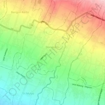
Name: Topografische Karte Donokerto, Höhe, Relief.
Durchschnittliche Höhe: 370 m
Minimale Höhe: 278 m
Maximale Höhe: 490 m
Andere topografische Karten
Klicken Sie auf eine Karte, um ihre Topografie, ihre Höhe und ihr Relief anzuzeigen.
Sidoagung
Indonesia > Special Region of Yogyakarta > Sleman Regency
Sidoagung, Godean, Sleman Regency, Special Region of Yogyakarta, Java, Indonesia
Durchschnittliche Höhe: 120 m
Ngipiksari
Indonesia > Special Region of Yogyakarta > Sleman Regency > Hargobinangun > Kaliurang
Ngipiksari, Kaliurang, Hargobinangun, Pakem, Sleman Regency, Special Region of Yogyakarta, Java, 55583, Indonesia
Durchschnittliche Höhe: 794 m
Wisdom park
Indonesia > Special Region of Yogyakarta > Sleman Regency > Catur tunggal
Wisdom park, Catur Tunggal, Depok, Sleman Regency, Special Region of Yogyakarta, 55281, Indonesia
Durchschnittliche Höhe: 136 m
Gunung Merapi National Park
Indonesia > Special Region of Yogyakarta > Sleman Regency > Hargobinangun
Gunung Merapi National Park, Hargobinangun, Pakem, Sleman Regency, Special Region of Yogyakarta, Java, Indonesia
Durchschnittliche Höhe: 1.150 m
Kaliurang
Indonesia > Special Region of Yogyakarta > Sleman Regency > Hargobinangun
Kaliurang, Hargobinangun, Pakem, Sleman Regency, Special Region of Yogyakarta, 55583, Indonesia
Durchschnittliche Höhe: 858 m
Sinduadi
Indonesia > Special Region of Yogyakarta > Sleman Regency
Sinduadi, Mlati, Sleman Regency, Special Region of Yogyakarta, Java, 55284, Indonesia
Durchschnittliche Höhe: 154 m
Embung Tambakboyo
Indonesia > Special Region of Yogyakarta > Sleman Regency > Condongcatur > Condongcatur
Embung Tambakboyo, Condongcatur, Depok, Sleman Regency, Special Region of Yogyakarta, Indonesia
Durchschnittliche Höhe: 164 m
Donoharjo
Indonesia > Special Region of Yogyakarta > Sleman Regency > Donoharjo
Donoharjo, Sleman Regency, Special Region of Yogyakarta, Indonesia
Durchschnittliche Höhe: 281 m
Girikerto
Indonesia > Special Region of Yogyakarta > Sleman Regency > Girikerto
Girikerto, Turi, Sleman Regency, Special Region of Yogyakarta, Indonesia
Durchschnittliche Höhe: 703 m
Condong Catur
Indonesia > Special Region of Yogyakarta > Sleman Regency > Condongcatur > Condong Catur
Condong Catur, Condongcatur, Depok, Sleman Regency, Special Region of Yogyakarta, 55283, Indonesia
Durchschnittliche Höhe: 163 m
Catur Tunggal
Indonesia > Special Region of Yogyakarta > Sleman Regency
Catur Tunggal, Depok, Sleman Regency, Special Region of Yogyakarta, Indonesia
Durchschnittliche Höhe: 143 m
Depok
Indonesia > Special Region of Yogyakarta > Sleman Regency
Depok, Sleman Regency, Special Region of Yogyakarta, Java, Indonesia
Durchschnittliche Höhe: 145 m