
Topografische Karte Toolik River
Interaktive Karte
Klicken Sie auf die Karte, um die Höhe anzuzeigen.
Über diese Karte
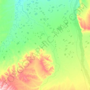
Name: Topografische Karte Toolik River, Höhe, Relief.
Ort: Toolik River, North Slope, Alaska, United States (69.48111 -149.52219 69.92506 -148.94732)
Durchschnittliche Höhe: 126 m
Minimale Höhe: 49 m
Maximale Höhe: 402 m
Andere topografische Karten
Klicken Sie auf eine Karte, um ihre Topografie, ihre Höhe und ihr Relief anzuzeigen.
Prudhoe Bay
United States > Alaska > North Slope
Prudhoe Bay, North Slope, Alaska, 99734, United States
Durchschnittliche Höhe: 10 m
Toolik Field Station
United States > Alaska > North Slope
Toolik Field Station, North Slope, Alaska, United States
Durchschnittliche Höhe: 740 m
Chandalar Shelf
United States > Alaska > North Slope
Chandalar Shelf, North Slope, Alaska, United States
Durchschnittliche Höhe: 974 m
Kaktovik
United States > Alaska > North Slope > Kaktovik
Kaktovik, North Slope, Alaska, 99747, United States
Durchschnittliche Höhe: 5 m
Point Barrow
United States > Alaska > North Slope
Point Barrow, North Slope, Alaska, United States
Durchschnittliche Höhe: 0 m
Deadhorse
United States > Alaska > North Slope
Deadhorse, North Slope, Alaska, 99734, United States
Durchschnittliche Höhe: 14 m
Utqiaġvik
United States > Alaska > North Slope
Utqiaġvik, North Slope, Alaska, 99273, United States
Durchschnittliche Höhe: 4 m