
Spenden
Rüsten Sie sich für Ihr nächstes Abenteuer:
Als Amazon-Partner erhält diese Website eine Provision für qualifizierte Käufe, ohne zusätzliche Kosten für Sie.
Topografische Karte Getxo
Klicken Sie auf die Karte, um die Höhe anzuzeigen.
Spenden
Rüsten Sie sich für Ihr nächstes Abenteuer:
Als Amazon-Partner erhält diese Website eine Provision für qualifizierte Käufe, ohne zusätzliche Kosten für Sie.
Über diese Karte
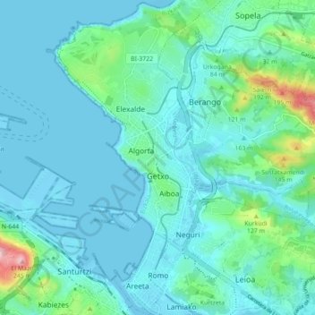
Name: Topografische Karte Getxo, Höhe, Relief.
Durchschnittliche Höhe: 36 m
Minimale Höhe: -3 m
Maximale Höhe: 240 m
Spenden
Rüsten Sie sich für Ihr nächstes Abenteuer:
Als Amazon-Partner erhält diese Website eine Provision für qualifizierte Käufe, ohne zusätzliche Kosten für Sie.
Andere topografische Karten
Klicken Sie auf eine Karte, um ihre Topografie, ihre Höhe und ihr Relief anzuzeigen.
Gebara
Spain > Autonomous Community of the Basque Country > Arabako lautada/Llanada Alavesa
Durchschnittliche Höhe: 574 m
Larraitz
Spain > Autonomous Community of the Basque Country > Abaltzisketa
Durchschnittliche Höhe: 477 m
Spenden
Rüsten Sie sich für Ihr nächstes Abenteuer:
Als Amazon-Partner erhält diese Website eine Provision für qualifizierte Käufe, ohne zusätzliche Kosten für Sie.
Gorbeia
Spain > Autonomous Community of the Basque Country > Gorbeialdea > Zeanuri
Durchschnittliche Höhe: 1.189 m
Marabi
Spain > Autonomous Community of the Basque Country > Amorebieta-Etxano
Durchschnittliche Höhe: 161 m
Spenden
Rüsten Sie sich für Ihr nächstes Abenteuer:
Als Amazon-Partner erhält diese Website eine Provision für qualifizierte Käufe, ohne zusätzliche Kosten für Sie.
Karakate
Spain > Autonomous Community of the Basque Country > Debabarrena > Soraluze
Durchschnittliche Höhe: 366 m
Santa Barbara
Spain > Autonomous Community of the Basque Country > Hernani > Sorgintxulo
Durchschnittliche Höhe: 68 m
Soil
Spain > Autonomous Community of the Basque Country > Arabako Mendialdea
Durchschnittliche Höhe: 898 m
Spenden
Rüsten Sie sich für Ihr nächstes Abenteuer:
Als Amazon-Partner erhält diese Website eine Provision für qualifizierte Käufe, ohne zusätzliche Kosten für Sie.
Bujal
Spain > Autonomous Community of the Basque Country > Añanako kuadrilla > Berantevilla
Durchschnittliche Höhe: 535 m
Araneta
Spain > Autonomous Community of the Basque Country > Gasteizko kuadrilla/Cuadrilla de Vitoria > Vitoria-Gasteiz > Bolívar
Durchschnittliche Höhe: 625 m
Soil
Spain > Autonomous Community of the Basque Country > Montaña Alavesa/Arabako Mendialdea
Durchschnittliche Höhe: 898 m
Makola
Spain > Autonomous Community of the Basque Country > Urola-Kosta > Azkoitia
Durchschnittliche Höhe: 515 m
Spenden
Rüsten Sie sich für Ihr nächstes Abenteuer:
Als Amazon-Partner erhält diese Website eine Provision für qualifizierte Käufe, ohne zusätzliche Kosten für Sie.
Fuente Oneri
Spain > Autonomous Community of the Basque Country > Arabako lautada/Llanada Alavesa > Agurain/Salvatierra
Durchschnittliche Höhe: 681 m
Iruka
Spain > Autonomous Community of the Basque Country > Debabarrena > Eibar
Durchschnittliche Höhe: 425 m
Torrea
Spain > Autonomous Community of the Basque Country > Debabarrena > Eibar
Durchschnittliche Höhe: 398 m
Spenden
Rüsten Sie sich für Ihr nächstes Abenteuer:
Als Amazon-Partner erhält diese Website eine Provision für qualifizierte Käufe, ohne zusätzliche Kosten für Sie.
Flysch
Spain > Autonomous Community of the Basque Country > Urola-Kosta > Zumaia
Durchschnittliche Höhe: 27 m
Barinatxe - La Salvaje
Spain > Autonomous Community of the Basque Country > Sopela
Durchschnittliche Höhe: 26 m
Lore-Toki
Spain > Autonomous Community of the Basque Country > Arabako Errioxa/Rioja Alavesa > Labastida/Bastida
Durchschnittliche Höhe: 499 m
Trevilla
Spain > Autonomous Community of the Basque Country > Karrantza Harana/Valle de Carranza > Concha
Durchschnittliche Höhe: 333 m
Spenden
Rüsten Sie sich für Ihr nächstes Abenteuer:
Als Amazon-Partner erhält diese Website eine Provision für qualifizierte Käufe, ohne zusätzliche Kosten für Sie.
Zorrotzarri
Spain > Autonomous Community of the Basque Country > Urnieta
Durchschnittliche Höhe: 291 m
Spenden
Rüsten Sie sich für Ihr nächstes Abenteuer:
Als Amazon-Partner erhält diese Website eine Provision für qualifizierte Käufe, ohne zusätzliche Kosten für Sie.
Floreaga
Spain > Autonomous Community of the Basque Country > Urola-Kosta > Azkoitia
Durchschnittliche Höhe: 266 m
Hondarribiko hondartza
Spain > Autonomous Community of the Basque Country > Gipuzkoako Bidasoa > Hondarribia
Durchschnittliche Höhe: 31 m
Monterredondo
Spain > Autonomous Community of the Basque Country > Añanako kuadrilla/Cuadrilla de Añana
Durchschnittliche Höhe: 875 m
Spenden
Rüsten Sie sich für Ihr nächstes Abenteuer:
Als Amazon-Partner erhält diese Website eine Provision für qualifizierte Käufe, ohne zusätzliche Kosten für Sie.
Buruntza Auzoa
Spain > Autonomous Community of the Basque Country > Andoain
Durchschnittliche Höhe: 143 m
Oñati
Spain > Autonomous Community of the Basque Country > Debagoiena > Oñati
Durchschnittliche Höhe: 488 m
Plaza de Larrazábal
Spain > Autonomous Community of the Basque Country > Bilbao
Durchschnittliche Höhe: 101 m
Spenden
Rüsten Sie sich für Ihr nächstes Abenteuer:
Als Amazon-Partner erhält diese Website eine Provision für qualifizierte Käufe, ohne zusätzliche Kosten für Sie.
Gautegiz Arteaga
Spain > Autonomous Community of the Basque Country > Gautegiz Arteaga > Gautegiz Arteaga
Durchschnittliche Höhe: 104 m
Zaldibar
Spain > Autonomous Community of the Basque Country > Zaldibar > Zaldibar
Durchschnittliche Höhe: 305 m
Soil
Spain > Autonomous Community of the Basque Country > Montaña Alavesa/Arabako Mendialdea
Durchschnittliche Höhe: 898 m