
Topografische Karte Levadia Municipal Unit
Interaktive Karte
Klicken Sie auf die Karte, um die Höhe anzuzeigen.
Über diese Karte
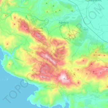
Name: Topografische Karte Levadia Municipal Unit, Höhe, Relief.
Durchschnittliche Höhe: 468 m
Minimale Höhe: 0 m
Maximale Höhe: 1.734 m
Andere topografische Karten
Klicken Sie auf eine Karte, um ihre Topografie, ihre Höhe und ihr Relief anzuzeigen.
Livadia
Greece > Thessaly and Central Greece > Regional Unit of Boeotia > Levadia Municipal Unit
Livadia, Levadia Municipal Unit, Municipality of Livadia, Regional Unit of Boeotia, Central Greece, Thessaly and Central Greece, 321 00, Greece
Durchschnittliche Höhe: 313 m
Pyli
Greece > Thessaly and Central Greece > Regional Unit of Boeotia > Δημοτική Ενότητα Δερβενοχωρίων
Pyli, Δημοτική Ενότητα Δερβενοχωρίων, Municipality of Tanagra, Regional Unit of Boeotia, Central Greece, Thessaly and Central Greece, 190 12, Greece
Durchschnittliche Höhe: 574 m
Δημοτική Ενότητα Δερβενοχωρίων
Greece > Thessaly and Central Greece > Regional Unit of Boeotia
Δημοτική Ενότητα Δερβενοχωρίων, Municipality of Tanagra, Regional Unit of Boeotia, Central Greece, Thessaly and Central Greece, Greece
Durchschnittliche Höhe: 417 m
Cheronia
Greece > Thessaly and Central Greece > Regional Unit of Boeotia > Cheronia
Cheronia, Χαιρώνεια - Ακόντιο, Κοινότητα Χαιρώνειας, Cheronia, Municipality of Livadia, Regional Unit of Boeotia, Central Greece, Thessaly and Central Greece, 321 00, Greece
Durchschnittliche Höhe: 147 m
Arachova
Greece > Thessaly and Central Greece > Regional Unit of Boeotia > Δημοτική Ενότητα Αραχώβης > Arachova
Arachova, Δημοτική Ενότητα Αραχώβης, Distomo-Arachova-Antikyra Municipality, Regional Unit of Boeotia, Central Greece, Thessaly and Central Greece, 32004, Greece
Durchschnittliche Höhe: 901 m
Tanagra
Greece > Thessaly and Central Greece > Regional Unit of Boeotia > Δημοτική Ενότητα Τανάγρας > Tanagra
Tanagra, Δημοτική Ενότητα Τανάγρας, Municipality of Tanagra, Regional Unit of Boeotia, Central Greece, Thessaly and Central Greece, 32009, Greece
Durchschnittliche Höhe: 231 m