

Topografische Karte Stroud
Klicken Sie auf die Karte, um die Höhe anzuzeigen.
Stroud
Stroud liegt im Westen der Cotswolds etwa 13 Kilometer südlich von Gloucester am River Frome. Die Stadt liegt direkt östlich von Stonehouse und einige Kilometer westlich von Chalford beziehungsweise nördlich von Nailsworth. Stroud liegt dabei nur auf etwa 50 Metern Höhe über Meeresspiegel in einer Region namens Golden Valleys, die sich in Stroud zu einem großen Tal vereinen. Abgesehen vom Stadtzentrum gibt es zahlreiche Ortsteile insbesondere westlich und östlich der Stadt. Je nach Definition umfasst die Stadt Stroud dabei nur das kleinere Civil Parish Stroud, oder auch noch weitere Civil Parishes im Umland, die eine sogenannte Built-up area sub division bilden. Daher liegt die Stadt insgesamt in Civil Parishes, wobei die Stadt im Prinzip nur aus acht Civil Parishes besteht, der neunte Civil Parish Minchinhampton umfasst nur die Ortslage Walls Quarry. Stroud ist daneben Zentrum eines urbanen Raums, der unter anderem auch Stonehouse umfasst.
Über diese Karte
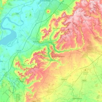
Name: Topografische Karte Stroud, Höhe, Relief.
Ort: Stroud, Gloucestershire, England, Vereinigtes Königreich (51.58984 -2.54081 51.85046 -2.06871)
Durchschnittliche Höhe: 113 m
Minimale Höhe: 0 m
Maximale Höhe: 302 m
Andere topografische Karten
Klicken Sie auf eine Karte, um ihre Topografie, ihre Höhe und ihr Relief anzuzeigen.
Upper Soudley
Vereinigtes Königreich > England > Gloucestershire > Forest of Dean
Durchschnittliche Höhe: 138 m
Elkstone
Vereinigtes Königreich > England > Gloucestershire > Cotswold District
Durchschnittliche Höhe: 234 m
Selsley Common
Vereinigtes Königreich > England > Gloucestershire > Stroud
Durchschnittliche Höhe: 108 m
Haresfield Beacon
Vereinigtes Königreich > England > Gloucestershire > Stroud
Durchschnittliche Höhe: 112 m