
Topografische Karte मनाङ
Interaktive Karte
Klicken Sie auf die Karte, um die Höhe anzuzeigen.
Über diese Karte
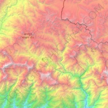
Name: Topografische Karte मनाङ, Höhe, Relief.
Ort: मनाङ, Provinz Gandaki, 33500, Nepal (28.44496 83.78724 28.90057 84.57149)
Durchschnittliche Höhe: 4.547 m
Minimale Höhe: 1.108 m
Maximale Höhe: 8.034 m
Der 2246 km² große Distrikt liegt direkt an der chinesischen Grenze im Zentralhimalaya. Seine Distriktnachbarn sind: Kaski, Lamjung, Gorkha, Mustang und Myagdi. Die Topografie wird bestimmt durch den Marsyangdi-Fluss, der am 5413 m hohen Thorong La entspringt. Dieser Pass bildet auch einen Übergang zum Distrikt Mustang nach Muktinath.
Andere topografische Karten
Klicken Sie auf eine Karte, um ihre Topografie, ihre Höhe und ihr Relief anzuzeigen.
मनास्लु
Nepal > Provinz Gandaki > Gorkha
मनास्लु, Chum Nubri, Gorkha, Provinz Gandaki, Nepal
Durchschnittliche Höhe: 7.069 m
सराङ्गकोट
Nepal > Provinz Gandaki > कास्की > Pokhara
सराङ्गकोट, Pokhara, कास्की, Provinz Gandaki, 00799, Nepal
Durchschnittliche Höhe: 1.139 m
Bandipur
Nepal > Provinz Gandaki > तनहुँ
Bandipur, तनहुँ, Provinz Gandaki, 00000, Nepal
Durchschnittliche Höhe: 698 m
Bhulbhule
Nepal > Provinz Gandaki > लमजुङ
Bhulbhule, Marsyangdi, लमजुङ, Provinz Gandaki, 36000, Nepal
Durchschnittliche Höhe: 1.257 m
Wāling
Nepal > Provinz Gandaki > स्याङ्जा
Wāling, Waling, स्याङ्जा, Provinz Gandaki, Nepal
Durchschnittliche Höhe: 969 m
Pokhara
Nepal > Provinz Gandaki > कास्की
Pokhara, कास्की, Provinz Gandaki, Nepal
Durchschnittliche Höhe: 1.203 m