
Topografische Karte Parroquia Morán
Interaktive Karte
Klicken Sie auf die Karte, um die Höhe anzuzeigen.
Über diese Karte
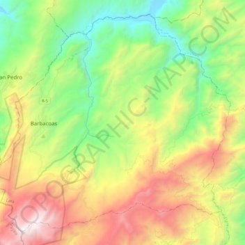
Name: Topografische Karte Parroquia Morán, Höhe, Relief.
Ort: Parroquia Morán, Municipio Morán, Estado Lara, Venezuela (9.73851 -70.10101 9.91472 -69.89973)
Durchschnittliche Höhe: 1.587 m
Minimale Höhe: 686 m
Maximale Höhe: 2.955 m
Andere topografische Karten
Klicken Sie auf eine Karte, um ihre Topografie, ihre Höhe und ihr Relief anzuzeigen.
Parroquia Bolívar
Venezuela > Estado Lara > Municipio Morán
Parroquia Bolívar, Municipio Morán, Estado Lara, 3018, Venezuela
Durchschnittliche Höhe: 1.034 m
Humocaro Bajo
Venezuela > Estado Lara > Municipio Morán
Humocaro Bajo, Parroquia Humocaro Bajo, Municipio Morán, Estado Lara, Venezuela
Durchschnittliche Höhe: 1.277 m
El Jabón
Venezuela > Estado Lara > Municipio Morán
El Jabón, Parroquia Humocaro Alto, Municipio Morán, Estado Lara, Venezuela
Durchschnittliche Höhe: 1.562 m