
Topografische Karte Bhimtal
Klicken Sie auf die Karte, um die Höhe anzuzeigen.
Über diese Karte
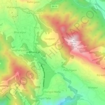
Name: Topografische Karte Bhimtal, Höhe, Relief.
Ort: Bhimtal, Nainital, Uttarakhand, 263136, India (29.31061 79.51417 29.39061 79.59417)
Durchschnittliche Höhe: 1.386 m
Minimale Höhe: 634 m
Maximale Höhe: 1.973 m
Andere topografische Karten
Klicken Sie auf eine Karte, um ihre Topografie, ihre Höhe und ihr Relief anzuzeigen.
Nainital
India > Uttarakhand > Nainital
Nainital is located in the Kumaon foothills of the outer Himalayas at a distance of 276 km (171 mi) from the state capital Dehradun and 314 km (195 mi) from New Delhi, the capital of India. Situated at an altitude of 1,938 metres (6,358 ft) above sea level, the town is set in a valley containing an eye-shaped…
Durchschnittliche Höhe: 2.059 m