
Topografische Karte Modiin-Maccabim-Reut
Interaktive Karte
Klicken Sie auf die Karte, um die Höhe anzuzeigen.
Über diese Karte
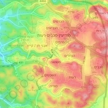
Name: Topografische Karte Modiin-Maccabim-Reut, Höhe, Relief.
Durchschnittliche Höhe: 240 m
Minimale Höhe: 147 m
Maximale Höhe: 320 m
הנחלים HaNachlim - The Rivers (Safdie) and משואה Masuah - Beacon (Givat C) are located towards the west of the city, and were planned by architect Moshe Safdie. Located in these neighborhoods are five commercial centers, a secondary school and three primary schools. The central street names are named after valleys in Israel, and the side streets are named after Israeli rivers and streets. The name "Masuah" was selected in order to represent the neighborhood's high altitude. Within the area consisting of the streets named after rivers and streams is the "Malibu" area, which, as with other areas, is colloquially named after the contractor who designed the neighborhood.
Andere topografische Karten
Klicken Sie auf eine Karte, um ihre Topografie, ihre Höhe und ihr Relief anzuzeigen.
Shoham
Shoham, Ramla Subdistrict, Center District, Israel
Durchschnittliche Höhe: 101 m
Beit Gamliel
Israel > Center District > Hevel Yavne Regional Council
Beit Gamliel, Hevel Yavne Regional Council, Rehovot Subdistrict, Center District, Israel
Durchschnittliche Höhe: 32 m
Kefar HaNagid
Israel > Center District > Gan Rave Regional Council
Kefar HaNagid, Gan Rave Regional Council, Rehovot Subdistrict, Center District, Israel
Durchschnittliche Höhe: 21 m
Rishon LeZion
Rishon LeZion, Rehovot Subdistrict, Center District, Israel
Durchschnittliche Höhe: 52 m
Kiryat Ekron
Kiryat Ekron, Rehovot Subdistrict, Center District, Israel
Durchschnittliche Höhe: 58 m
Palmachim
Israel > Center District > Gan Rave Regional Council
Palmachim, Gan Rave Regional Council, Rehovot Subdistrict, Center District, Israel
Durchschnittliche Höhe: 9 m
Netanya
Netanya, haSharon Subdistrict, Center District, Israel
Durchschnittliche Höhe: 20 m
Nof Ayalon
Israel > Center District > Gezer Regional Council
Nof Ayalon, Gezer Regional Council, Ramla Subdistrict, Center District, 7173709, Israel
Durchschnittliche Höhe: 200 m
Tel Gezer
Israel > Center District > Gezer Regional Council
Tel Gezer, Gezer Regional Council, Ramla Subdistrict, Center District, Israel
Durchschnittliche Höhe: 169 m
Hod HaSharon
Hod HaSharon, Petah Tikva Subdistrict, Center District, Israel
Durchschnittliche Höhe: 44 m
Kfar Haro'e
Israel > Center District > Emek Hefer Regional Council
Kfar Haro'e, Emek Hefer Regional Council, haSharon Subdistrict, Center District, Israel
Durchschnittliche Höhe: 15 m
Drom HaSharon Regional Council
Drom HaSharon Regional Council, Petah Tikva Subdistrict, Center District, Israel
Durchschnittliche Höhe: 58 m
Tzafria
Israel > Center District > Sdot Dan Regional Council
Tzafria, Sdot Dan Regional Council, Ramla Subdistrict, Center District, 5020000, Israel
Durchschnittliche Höhe: 34 m
Brener Regional Council
Brener Regional Council, Rehovot Subdistrict, Center District, 972, Israel
Durchschnittliche Höhe: 46 m
Yavne
Yavne, Rehovot Subdistrict, Center District, Israel
Durchschnittliche Höhe: 26 m
Nehalim
Israel > Center District > Hevel Modiin Regional Council
Nehalim, Hevel Modiin Regional Council, Petah Tikva Subdistrict, Center District, 4973353, Israel
Durchschnittliche Höhe: 50 m
Giv'at Koah
Israel > Center District > Hevel Modiin Regional Council
Giv'at Koah, Hevel Modiin Regional Council, Petah Tikva Subdistrict, Center District, 4082027, Israel
Durchschnittliche Höhe: 76 m
Yad Hanna
Israel > Center District > Emek Hefer Regional Council
Yad Hanna, Emek Hefer Regional Council, haSharon Subdistrict, Center District, 4284200, Israel
Durchschnittliche Höhe: 52 m
Meishar
Israel > Center District > Gderot Regional Council
Meishar, Gderot Regional Council, Rehovot Subdistrict, Center District, Israel
Durchschnittliche Höhe: 51 m
Gezer Regional Council
Gezer Regional Council, Ramla Subdistrict, Center District, Israel
Durchschnittliche Höhe: 134 m
Yesodot
Israel > Center District > Nahal Sorek Regional Council
Yesodot, Nahal Sorek Regional Council, Rehovot Subdistrict, Center District, 7680400, Israel
Durchschnittliche Höhe: 98 m
Eyal
Israel > Center District > Drom HaSharon Regional Council
Eyal, Drom HaSharon Regional Council, Petah Tikva Subdistrict, Center District, Israel
Durchschnittliche Höhe: 75 m
Palmahim
Israel > Center District > Gan Rave Regional Council
Palmahim, Gan Rave Regional Council, Rehovot Subdistrict, Center District, Israel
Durchschnittliche Höhe: 9 m
Modiin-Maccabim-Reut
Modiin-Maccabim-Reut, Ramla Subdistrict, Center District, Israel
Durchschnittliche Höhe: 199 m
Kafr Bara
Kafr Bara, Petah Tikva Subdistrict, Center District, Israel
Durchschnittliche Höhe: 87 m
Ramat HaKovesh
Israel > Center District > Drom HaSharon Regional Council
Ramat HaKovesh, Drom HaSharon Regional Council, Petah Tikva Subdistrict, Center District, 4060056, Israel
Durchschnittliche Höhe: 65 m
Kfar Daniel
Israel > Center District > Hevel Modiin Regional Council
Kfar Daniel, Hevel Modiin Regional Council, Ramla Subdistrict, Center District, Israel
Durchschnittliche Höhe: 90 m
Hadassim
Israel > Center District > Even Yehuda
Hadassim, Even Yehuda, haSharon Subdistrict, Center District, 4250519, Israel
Durchschnittliche Höhe: 36 m
Kfar Saba
Kfar Saba, Petah Tikva Subdistrict, Center District, Israel
Durchschnittliche Höhe: 51 m
Rishon LeZion
Rishon LeZion, Rehovot Subdistrict, Center District, Israel
Durchschnittliche Höhe: 43 m
Beer Yaakov
Israel > Center District > Beer Yaakov
Beer Yaakov, Ramla Subdistrict, Center District, 7031011, Israel
Durchschnittliche Höhe: 67 m
Petah Tikva
Israel > Center District > Petah Tikva
Petah Tikva, Savyon Ganei Yehuda, Petah Tikva Subdistrict, Center District, 4926040, Israel
Durchschnittliche Höhe: 83 m
Kfar Ruth
Israel > Center District > Hevel Modiin Regional Council > Kfar Ruth
Kfar Ruth, Hevel Modiin Regional Council, Ramla Subdistrict, Center District, 7177657, Israel
Durchschnittliche Höhe: 277 m
Yavne
Israel > Center District > Yavne
Yavne, Rehovot Subdistrict, Center District, Israel
Durchschnittliche Höhe: 27 m
Netanya
Netanya, haSharon Subdistrict, Center District, 42***, Israel
Durchschnittliche Höhe: 20 m
Gedera
Gedera, Rehovot Subdistrict, Center District, Israel
Durchschnittliche Höhe: 56 m
Rosh HaAyin
Israel > Center District > Rosh HaAyin
Rosh HaAyin, Savyon Ganei Yehuda, Petah Tikva Subdistrict, Center District, Israel
Durchschnittliche Höhe: 80 m
Givat Shmuel
Israel > Center District > Petah Tikva Subdistrict > Givat Shmuel
Givat Shmuel, Petah Tikva Subdistrict, Center District, Israel
Durchschnittliche Höhe: 50 m
Marja
Israel > Center District > Zemer > Marja
Marja, Zemer, haSharon Subdistrict, Center District, 3884500, Israel
Durchschnittliche Höhe: 96 m
Ein Vered
Israel > Center District > Lev HaSharon Regional Council > Ein Vered
Ein Vered, Lev HaSharon Regional Council, haSharon Subdistrict, Center District, Israel
Durchschnittliche Höhe: 63 m
Kfar Mordechay
Israel > Center District > Gderot Regional Council
Kfar Mordechay, Gderot Regional Council, Rehovot Subdistrict, Center District, Israel
Durchschnittliche Höhe: 41 m
Ramot HaShavim
Israel > Center District > Ramot HaShavim
Ramot HaShavim, Petah Tikva Subdistrict, Center District, Israel
Durchschnittliche Höhe: 60 m
Kfar Bilu
Israel > Center District > Gezer Regional Council > Kfar Bilu
Kfar Bilu, Gezer Regional Council, Ramla Subdistrict, Center District, Israel
Durchschnittliche Höhe: 65 m
Sdot Dan Regional Council
Israel > Center District > Sdot Dan Regional Council
Sdot Dan Regional Council, Ramla Subdistrict, Center District, Israel
Durchschnittliche Höhe: 46 m
Petah Tikva
Petah Tikva, Petah Tikva Subdistrict, Center District, Israel
Durchschnittliche Höhe: 37 m
Yavne
Israel > Center District > Yavne
Yavne, Rehovot Subdistrict, Center District, Israel
Durchschnittliche Höhe: 27 m
Matzliah
Israel > Center District > Matzliah
Matzliah, Ramla Subdistrict, Center District, Israel
Durchschnittliche Höhe: 82 m
Ahisamakh
Israel > Center District > Ahisamakh
Ahisamakh, Ramla Subdistrict, Center District, Israel
Durchschnittliche Höhe: 67 m
Raanana
Raanana, Petah Tikva Subdistrict, Center District, Israel
Durchschnittliche Höhe: 49 m
Aseret
Israel > Center District > Aseret
Aseret, Rehovot Subdistrict, Center District, Israel
Durchschnittliche Höhe: 50 m