
Spenden
Rüsten Sie sich für Ihr nächstes Abenteuer:
Als Amazon-Partner erhält diese Website eine Provision für qualifizierte Käufe, ohne zusätzliche Kosten für Sie.
Topografische Karte Muntanyola
Klicken Sie auf die Karte, um die Höhe anzuzeigen.
Spenden
Rüsten Sie sich für Ihr nächstes Abenteuer:
Als Amazon-Partner erhält diese Website eine Provision für qualifizierte Käufe, ohne zusätzliche Kosten für Sie.
Muntanyola
The village of Muntanyola is a-typical in that it does not have a center. 75% of the municipality's area consists of forested hills between 650 and 1000 m. altitude, with scattered farms and fields. The build-up area is in the higher elevations and mainly consists of two real estate developments - in Spanish: 'urbanizations' - called Muntanyola and Fontanelles, respectively. Both these neighbourhoods consist of lanes with upmarket free-standing villa's with large gardens. Centrally located in the 'Muntanyola urbanization' are the school, a tennis court, sports hall, swimming pool, playground and restaurant. The church and town hall stand rather isolated in the hills on the northern side of the Muntanyola-development. The municipality also includes the old hamlet of Múnter in its lower elevations, sloping down to the Plain of Vic (Plana de Vic). The municipality is also odd in that its territory consists of four non-contiguous areas, i.e. a main area with three exclaves. Muntanyola, Fontanelles and Múnter are all in the main area, but Múnter can be reached from Muntanyola by a rural path or via the territory of the adjacent municipality of Tona
Spenden
Rüsten Sie sich für Ihr nächstes Abenteuer:
Als Amazon-Partner erhält diese Website eine Provision für qualifizierte Käufe, ohne zusätzliche Kosten für Sie.
Über diese Karte
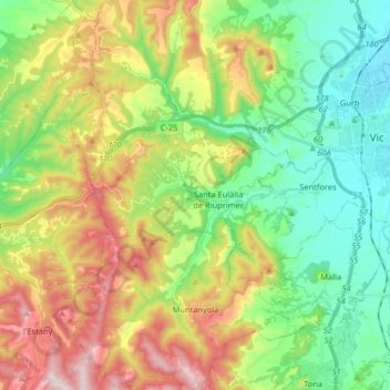
Name: Topografische Karte Muntanyola, Höhe, Relief.
Ort: Muntanyola, Osona, Barcelona, Catalonia, 08529, Spain (41.85207 2.09069 41.97270 2.23168)
Durchschnittliche Höhe: 678 m
Minimale Höhe: 470 m
Maximale Höhe: 1.029 m
Spenden
Rüsten Sie sich für Ihr nächstes Abenteuer:
Als Amazon-Partner erhält diese Website eine Provision für qualifizierte Käufe, ohne zusätzliche Kosten für Sie.
Andere topografische Karten
Klicken Sie auf eine Karte, um ihre Topografie, ihre Höhe und ihr Relief anzuzeigen.