
Topografische Karte Mattituck
Interaktive Karte
Klicken Sie auf die Karte, um die Höhe anzuzeigen.
Über diese Karte
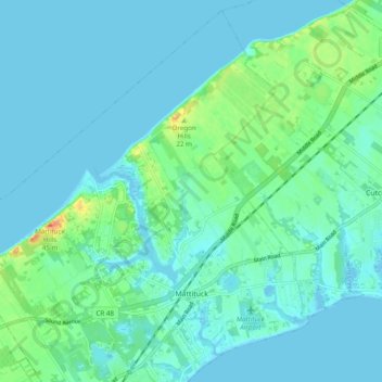
Name: Topografische Karte Mattituck, Höhe, Relief.
Durchschnittliche Höhe: 8 m
Minimale Höhe: -4 m
Maximale Höhe: 41 m
Andere topografische Karten
Klicken Sie auf eine Karte, um ihre Topografie, ihre Höhe und ihr Relief anzuzeigen.
Fishers Island
United States > New York > Suffolk County > Town of Southold
Fishers Island, Town of Southold, Suffolk County, New York, 06390, United States
Durchschnittliche Höhe: 0 m
New Suffolk
United States > New York > Suffolk County > Town of Southold
New Suffolk, Town of Southold, Suffolk County, New York, 11956, United States
Durchschnittliche Höhe: 2 m
Cutchogue
United States > New York > Suffolk County > Town of Southold
Cutchogue, Town of Southold, Suffolk County, New York, 11935, United States
Durchschnittliche Höhe: 7 m
East Marion
United States > New York > Suffolk County > Town of Southold
East Marion, Town of Southold, Suffolk County, New York, 11939, United States
Durchschnittliche Höhe: 4 m
Orient
United States > New York > Suffolk County > Town of Southold
Orient, Town of Southold, Suffolk County, New York, United States
Durchschnittliche Höhe: 2 m