
Topografische Karte Salisbury
Interaktive Karte
Klicken Sie auf die Karte, um die Höhe anzuzeigen.
Salisbury
According to the United States Census Bureau, the city has a total area of 13.87 square miles (35.92 km2), of which 13.40 square miles (34.71 km2) is land and 0.47 square miles (1.22 km2) is water. The city has a varying elevation of 17 to 45 feet (5.2 to 13.7 m) above sea level.
Über diese Karte
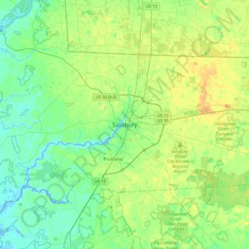
Name: Topografische Karte Salisbury, Höhe, Relief.
Ort: Salisbury, Wicomico County, Maryland, 21803, United States (38.20603 -75.76100 38.52603 -75.44100)
Durchschnittliche Höhe: 11 m
Minimale Höhe: -3 m
Maximale Höhe: 32 m