
Topografische Karte Indre-et-Loire
Interaktive Karte
Klicken Sie auf die Karte, um die Höhe anzuzeigen.
Über diese Karte
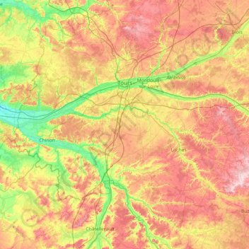
Name: Topografische Karte Indre-et-Loire, Höhe, Relief.
Ort: Indre-et-Loire, Centre-Val de Loire, Metropolitan France, France (46.73666 0.05276 47.70979 1.36594)
Durchschnittliche Höhe: 98 m
Minimale Höhe: 24 m
Maximale Höhe: 198 m
Andere topografische Karten
Klicken Sie auf eine Karte, um ihre Topografie, ihre Höhe und ihr Relief anzuzeigen.
Condé
France > Centre-Val de Loire > Indre
Condé, Issoudun, Indre, Centre-Val de Loire, Metropolitan France, 36100, France
Durchschnittliche Höhe: 152 m
Les Caves
France > Centre-Val de Loire > Loiret > Beaugency
Les Caves, Beaugency, Orléans, Loiret, Centre-Val de Loire, Metropolitan France, 45190, France
Durchschnittliche Höhe: 92 m
Sancerre
France > Centre-Val de Loire > Cher
Sancerre, Bourges, Cher, Centre-Val de Loire, Metropolitan France, 18300, France
Durchschnittliche Höhe: 212 m
Chanteau
France > Centre-Val de Loire > Loiret
Chanteau, Orléans, Loiret, Centre-Val de Loire, Metropolitan France, 45400, France
Durchschnittliche Höhe: 128 m
Richelieu
France > Centre-Val de Loire > Indre-et-Loire
Richelieu, Chinon, Indre-et-Loire, Centre-Val de Loire, Metropolitan France, 37120, France
Durchschnittliche Höhe: 59 m
Saint-Roch
France > Centre-Val de Loire > Indre-et-Loire
Saint-Roch, Chinon, Indre-et-Loire, Centre-Val de Loire, Metropolitan France, 37390, France
Durchschnittliche Höhe: 95 m
Le Blanc
France > Centre-Val de Loire > Indre
Le Blanc, Indre, Centre-Val de Loire, Metropolitan France, 36300, France
Durchschnittliche Höhe: 111 m
Saint-Marcel
France > Centre-Val de Loire > Indre
Saint-Marcel, Châteauroux, Indre, Centre-Val de Loire, Metropolitan France, 36200, France
Durchschnittliche Höhe: 149 m
Saint-Avertin
France > Centre-Val de Loire > Indre-et-Loire
Saint-Avertin, Arrondissement de Tours, Indre-et-Loire, Centre-Val de Loire, Metropolitan France, 37550, France
Durchschnittliche Höhe: 81 m
Chavignol
France > Centre-Val de Loire > Cher > Amigny
Chavignol, Amigny, Sancerre, Bourges, Cher, Centre-Val de Loire, Metropolitan France, 18300, France
Durchschnittliche Höhe: 282 m
Chavin
France > Centre-Val de Loire > Indre
Chavin, Châteauroux, Indre, Centre-Val de Loire, Metropolitan France, 36200, France
Durchschnittliche Höhe: 230 m
Raymond
France > Centre-Val de Loire > Cher
Raymond, Saint-Amand-Montrond, Cher, Centre-Val de Loire, Metropolitan France, 18130, France
Durchschnittliche Höhe: 187 m
Saint-Florent-sur-Cher
France > Centre-Val de Loire > Cher
Saint-Florent-sur-Cher, Bourges, Cher, Centre-Val de Loire, Metropolitan France, 18400, France
Durchschnittliche Höhe: 149 m
Cher
Cher, Centre-Val de Loire, Metropolitan France, France
Durchschnittliche Höhe: 207 m
Chartres
France > Centre-Val de Loire > Eure-et-Loir
Chartres, Eure-et-Loir, Centre-Val de Loire, Metropolitan France, 28000, France
Durchschnittliche Höhe: 150 m