
Topografische Karte Zhangjiakou
Interaktive Karte
Klicken Sie auf die Karte, um die Höhe anzuzeigen.
Über diese Karte
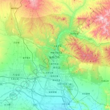
Name: Topografische Karte Zhangjiakou, Höhe, Relief.
Durchschnittliche Höhe: 959 m
Minimale Höhe: 633 m
Maximale Höhe: 1.764 m
Lying in between the Mongolian Plateau and the North China Plain, Zhangjiakou has a somewhat rugged topography characterized by high mountains, deep valleys, and rocky pathways. As a result, it serves as a perfect natural screen for Beijing, which has made it a strategic priority militarily since ancient times. It is called "The Gateway to Beijing" and "The Mountain City beyond the Great Wall". The grand Yan Mountain, the towering Taihang Mountain, the vast grasslands, and the meandering Sangyang River converge here. The city government has regarded tourism as a major driving force of the city's economy and continues to develop the industry.
Andere topografische Karten
Klicken Sie auf eine Karte, um ihre Topografie, ihre Höhe und ihr Relief anzuzeigen.
Chongli District
China > Hebei > Zhangjiakou
Chongli District, Zhangjiakou, Hebei, 076300, China
Durchschnittliche Höhe: 1.448 m
Huailai County
China > Hebei > Zhangjiakou
Huailai County, Zhangjiakou, Hebei, China
Durchschnittliche Höhe: 840 m