
Topografische Karte Condado de Kenton
Interaktive Karte
Klicken Sie auf die Karte, um die Höhe anzuzeigen.
Über diese Karte
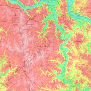
Name: Topografische Karte Condado de Kenton, Höhe, Relief.
Ort: Condado de Kenton, Kentucky, Estados Unidos de América (38.78992 -84.62370 39.09992 -84.41749)
Durchschnittliche Höhe: 233 m
Minimale Höhe: 135 m
Maximale Höhe: 293 m
Andere topografische Karten
Klicken Sie auf eine Karte, um ihre Topografie, ihre Höhe und ihr Relief anzuzeigen.
Pongo
Estados Unidos de América > Kentucky > Pongo
Pongo, Rockcastle County, Kentucky, Estados Unidos de América
Durchschnittliche Höhe: 346 m
Little Georgetown
Estados Unidos de América > Kentucky > Little Georgetown
Little Georgetown, Fayette County, Kentucky, 40513, Estados Unidos de América
Durchschnittliche Höhe: 285 m
Shelbyville
Estados Unidos de América > Kentucky > Shelbyville
Shelbyville, Shelby County, Kentucky, 40065, Estados Unidos de América
Durchschnittliche Höhe: 232 m
Westwood
Estados Unidos de América > Kentucky > Westwood
Westwood, Jefferson County, Kentucky, Estados Unidos de América
Durchschnittliche Höhe: 196 m