
Topografische Karte Aegean
Interaktive Karte
Klicken Sie auf die Karte, um die Höhe anzuzeigen.
Über diese Karte
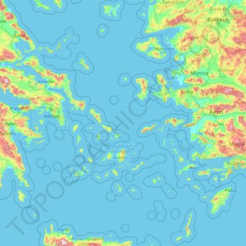
Name: Topografische Karte Aegean, Höhe, Relief.
Ort: Aegean, Greece (35.23795 24.06581 40.10085 29.72970)
Durchschnittliche Höhe: 124 m
Minimale Höhe: -2 m
Maximale Höhe: 2.305 m
Andere topografische Karten
Klicken Sie auf eine Karte, um ihre Topografie, ihre Höhe und ihr Relief anzuzeigen.
Santorini
Greece > Aegean > Thira Regional Unit > Thira Municipal Unit
Santorini, Thira Municipal Unit, Municipality of Thira, Thira Regional Unit, South Aegean, Aegean, Greece
Durchschnittliche Höhe: 30 m
Margarites
Greece > Aegean > Samos Regional Unit > Municipal Unit of Vathy > Manolates
Margarites, Manolates, Municipal Unit of Vathy, Municipality of Eastern Samos, Samos Regional Unit, Northern Aegean, Aegean, 832 00, Greece
Durchschnittliche Höhe: 308 m
Plakka Park
Greece > Aegean > Lesbos Regional Unit > Σίγρι
Plakka Park, Σίγρι, Municipality of Western Lesvos, Lesbos Regional Unit, Northern Aegean, Aegean, 811 12, Greece
Durchschnittliche Höhe: 35 m
Paros
Greece > Aegean > Paros Regional Unit
Paros, Paros Regional Unit, South Aegean, Aegean, Greece
Durchschnittliche Höhe: 69 m
Patmos
Greece > Aegean > Kalmynos Regional Unit > Patmos
Patmos, Patmos Municipality, Kalmynos Regional Unit, South Aegean, Aegean, 855 00, Greece
Durchschnittliche Höhe: 15 m
Papa
Greece > Aegean > Naxos Regional Unit > Donousa Municipal Unit
Papa, Donousa Municipal Unit, Municipality of Naxos and the Lesser Cyclades, Naxos Regional Unit, South Aegean, Aegean, Greece
Durchschnittliche Höhe: 121 m
Panteli
Greece > Aegean > Vromolithos
Panteli, Vromolithos, Δήμος Λέρου, Kalmynos Regional Unit, South Aegean Region, Aegean, 854 00, Greece
Durchschnittliche Höhe: 33 m
Thira Municipal Unit
Greece > Aegean > Thira Municipal Unit
Thira Municipal Unit, Δήμος Θήρας, Thira Regional Unit, South Aegean Region, Aegean, Greece
Durchschnittliche Höhe: 12 m
Notio Aspronisi West
Notio Aspronisi West, Δήμος Λειψών, Kalmynos Regional Unit, South Aegean Region, Aegean, Greece
Durchschnittliche Höhe: 2 m
Chios
Greece > Aegean > Chios Regional Unit
Chios, Chios Regional Unit, Northern Aegean, Aegean, Greece
Durchschnittliche Höhe: 99 m