
Topografische Karte Bear
Interaktive Karte
Klicken Sie auf die Karte, um die Höhe anzuzeigen.
Über diese Karte
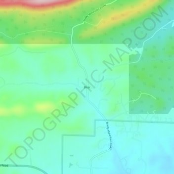
Name: Topografische Karte Bear, Höhe, Relief.
Ort: Bear, Garland County, Arkansas, 71968, United States (34.51453 -93.29380 34.55453 -93.25380)
Durchschnittliche Höhe: 216 m
Minimale Höhe: 154 m
Maximale Höhe: 405 m
Andere topografische Karten
Klicken Sie auf eine Karte, um ihre Topografie, ihre Höhe und ihr Relief anzuzeigen.
Lake Ouachita
United States > Arkansas > Garland County
Lake Ouachita, Garland County, Arkansas, United States
Durchschnittliche Höhe: 241 m
Hot Springs Village
United States > Arkansas > Garland County > Hot Springs Village
Hot Springs Village, Garland County, Arkansas, 71909, United States
Durchschnittliche Höhe: 226 m
Garland County
United States > Arkansas > Garland County
Garland County, Arkansas, United States
Durchschnittliche Höhe: 224 m
Hot Springs
United States > Arkansas > Garland County
Hot Springs, Garland County, Arkansas, United States
Durchschnittliche Höhe: 172 m