
Topografische Karte Boundary Waters Canoe Area Wilderness
Interaktive Karte
Klicken Sie auf die Karte, um die Höhe anzuzeigen.
Über diese Karte
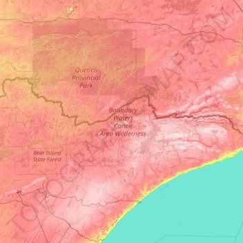
Name: Topografische Karte Boundary Waters Canoe Area Wilderness, Höhe, Relief.
Durchschnittliche Höhe: 423 m
Minimale Höhe: 176 m
Maximale Höhe: 683 m
Andere topografische Karten
Klicken Sie auf eine Karte, um ihre Topografie, ihre Höhe und ihr Relief anzuzeigen.
Isabella
United States > Minnesota > Lake County
Isabella, Lake County, Minnesota, United States
Durchschnittliche Höhe: 594 m
Turtle Lake
United States > Minnesota > Lake County
Turtle Lake, Lake County, Minnesota, United States
Durchschnittliche Höhe: 458 m
Two Harbors
United States > Minnesota > Lake County
Two Harbors, Lake County, Minnesota, United States
Durchschnittliche Höhe: 221 m
Washington Island
United States > Minnesota > Lake County
Washington Island, Lake County, Minnesota, United States
Durchschnittliche Höhe: 401 m
Bowstring Lake
United States > Minnesota > Lake County
Bowstring Lake, Lake County, Minnesota, United States
Durchschnittliche Höhe: 498 m
Snowbank Lake
United States > Minnesota > Lake County
Snowbank Lake, Lake County, Minnesota, United States
Durchschnittliche Höhe: 441 m
Bill Lake
United States > Minnesota > Lake County
Bill Lake, Lake County, Minnesota, United States
Durchschnittliche Höhe: 510 m
Ennis Lake
United States > Minnesota > Lake County
Ennis Lake, Fall Lake Township, Lake County, Minnesota, United States
Durchschnittliche Höhe: 445 m
Crooked Lake
United States > Minnesota > Lake County
Crooked Lake, Lake County, Minnesota, United States
Durchschnittliche Höhe: 533 m
Dorothy Lake
United States > Minnesota > Lake County
Dorothy Lake, Lake County, Minnesota, United States
Durchschnittliche Höhe: 491 m
Sable Lake
United States > Minnesota > Lake County
Sable Lake, Lake County, Minnesota, United States
Durchschnittliche Höhe: 487 m
Finland
United States > Minnesota > Lake County
Finland, Lake County, Minnesota, 55603, United States
Durchschnittliche Höhe: 425 m
Boga Lake
United States > Minnesota > Lake County
Boga Lake, Lake County, Minnesota, United States
Durchschnittliche Höhe: 482 m