
Topografische Karte Noville
Interaktive Karte
Klicken Sie auf die Karte, um die Höhe anzuzeigen.
Über diese Karte
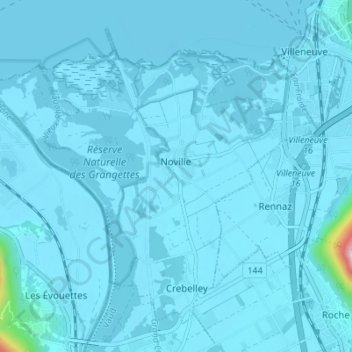
Name: Topografische Karte Noville, Höhe, Relief.
Ort: Noville, District d'Aigle, Waadland, 1845, Zwitserland (46.35986 6.85882 46.39981 6.92750)
Durchschnittliche Höhe: 384 m
Minimale Höhe: 369 m
Maximale Höhe: 884 m
Andere topografische Karten
Klicken Sie auf eine Karte, um ihre Topografie, ihre Höhe und ihr Relief anzuzeigen.
Leysin
Zwitserland > Waadland > District d'Aigle
Leysin, District d'Aigle, Waadland, 1854, Zwitserland
Durchschnittliche Höhe: 1.352 m
Vallée du Rhône
Zwitserland > Waadland > District d'Aigle
Vallée du Rhône, District d'Aigle, Waadland, 1902, Zwitserland
Durchschnittliche Höhe: 1.378 m
Villars-sur-Ollon
Zwitserland > Waadland > District d'Aigle
Villars-sur-Ollon, Ollon, District d'Aigle, Waadland, 1884, Zwitserland
Durchschnittliche Höhe: 1.293 m
Aigle
Zwitserland > Waadland > District d'Aigle
Aigle, District d'Aigle, Waadland, 1860, Zwitserland
Durchschnittliche Höhe: 647 m
Gryon
Zwitserland > Waadland > District d'Aigle
Gryon, District d'Aigle, Waadland, 1882, Zwitserland
Durchschnittliche Höhe: 1.240 m