
Topografische Karte Mount Elbert
Interaktive Karte
Klicken Sie auf die Karte, um die Höhe anzuzeigen.
Über diese Karte
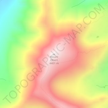
Name: Topografische Karte Mount Elbert, Höhe, Relief.
Ort: Mount Elbert, Lake County, Colorado, United States (39.11793 -106.44510 39.11803 -106.44500)
Durchschnittliche Höhe: 3.958 m
Minimale Höhe: 3.421 m
Maximale Höhe: 4.394 m
The summit of Mount Elbert at 14,440 feet (4401.2 m) elevation is the highest summit of the Rocky Mountains of North America, the highest point in the U.S. State of Colorado, and the second-highest summit in the contiguous United States after Mount Whitney. The ultra-prominent fourteener is the highest peak in the Sawatch Range, as well as the highest point in the entire Mississippi River drainage basin. Mount Elbert is located in San Isabel National Forest, 12.1 miles (19.4 km) southwest (bearing 223°) of the City of Leadville in Lake County, Colorado.
Andere topografische Karten
Klicken Sie auf eine Karte, um ihre Topografie, ihre Höhe und ihr Relief anzuzeigen.
Mount Sherman
United States > Colorado > Lake County
Mount Sherman, Lake County, Colorado, United States
Durchschnittliche Höhe: 3.989 m
Leadville
United States > Colorado > Lake County
Leadville, Lake County, Colorado, 80461, United States
Durchschnittliche Höhe: 3.106 m
Leadville
United States > Colorado > Lake County
Leadville, Lake County, Colorado, 80461, United States
Durchschnittliche Höhe: 3.106 m
Lake County
United States > Colorado > Lake County
Lake County, Colorado, United States
Durchschnittliche Höhe: 3.398 m