
Topografische Karte Municipality of Galatsi
Interaktive Karte
Klicken Sie auf die Karte, um die Höhe anzuzeigen.
Über diese Karte
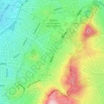
Name: Topografische Karte Municipality of Galatsi, Höhe, Relief.
Durchschnittliche Höhe: 176 m
Minimale Höhe: 87 m
Maximale Höhe: 317 m
Andere topografische Karten
Klicken Sie auf eine Karte, um ihre Topografie, ihre Höhe und ihr Relief anzuzeigen.
Athens
Greece > Attica > Regional Unit of Central Athens
Athens, Municipality of Athens, Regional Unit of Central Athens, Attica, 105 57, Greece
Durchschnittliche Höhe: 168 m
Municipality of Zografos
Greece > Attica > Regional Unit of Central Athens
Municipality of Zografos, Regional Unit of Central Athens, Attica, Greece
Durchschnittliche Höhe: 333 m
Municipality of Dafni - Ymittos
Greece > Attica > Regional Unit of Central Athens
Municipality of Dafni - Ymittos, Regional Unit of Central Athens, Attica, Greece
Durchschnittliche Höhe: 128 m
Areopagus
Greece > Attica > Regional Unit of Central Athens > Athens
Areopagus, Athens, Municipality of Athens, Regional Unit of Central Athens, Attica, 105 55, Greece
Durchschnittliche Höhe: 75 m