
Topografische Karte Appalachian
Interaktive Karte
Klicken Sie auf die Karte, um die Höhe anzuzeigen.
Über diese Karte
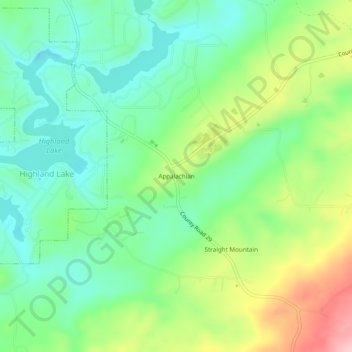
Name: Topografische Karte Appalachian, Höhe, Relief.
Ort: Appalachian, Blount County, Alabama, United States (33.86482 -86.42193 33.90482 -86.38193)
Durchschnittliche Höhe: 324 m
Minimale Höhe: 262 m
Maximale Höhe: 443 m
Andere topografische Karten
Klicken Sie auf eine Karte, um ihre Topografie, ihre Höhe und ihr Relief anzuzeigen.
Sulpher Springs
United States > Alabama > Blount County
Sulpher Springs, Blount County, Alabama, United States
Durchschnittliche Höhe: 129 m
Nyota
United States > Alabama > Blount County
Nyota, Blount County, Alabama, 35172, United States
Durchschnittliche Höhe: 142 m
Snead
United States > Alabama > Blount County
Snead, Blount County, Alabama, United States
Durchschnittliche Höhe: 238 m