
Spenden
Rüsten Sie sich für Ihr nächstes Abenteuer:
Als Amazon-Partner erhält diese Website eine Provision für qualifizierte Käufe, ohne zusätzliche Kosten für Sie.
Topografische Karte Roosevelt
Klicken Sie auf die Karte, um die Höhe anzuzeigen.
Spenden
Rüsten Sie sich für Ihr nächstes Abenteuer:
Als Amazon-Partner erhält diese Website eine Provision für qualifizierte Käufe, ohne zusätzliche Kosten für Sie.
Roosevelt
Roosevelt is situated on U.S. Route 40 in the northeast corner of the state, south of the Uinta Mountains, at an elevation of 5,250 feet (1,600 m). The town was incorporated at a mass meeting of 44 citizens on 21 February 1913. From 1906 to 1914 Roosevelt was in Wasatch County, but in 1914 Duchesne County was formed from part of Wasatch County, and, as the largest town in the county, Roosevelt anticipated becoming the county seat. However, when the total county-wide vote came in, the seat went to Duchesne.
Spenden
Rüsten Sie sich für Ihr nächstes Abenteuer:
Als Amazon-Partner erhält diese Website eine Provision für qualifizierte Käufe, ohne zusätzliche Kosten für Sie.
Über diese Karte
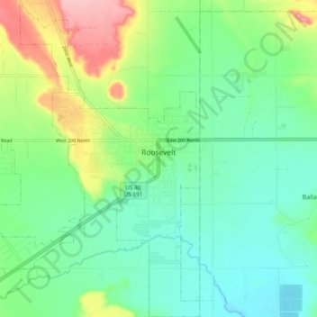
Name: Topografische Karte Roosevelt, Höhe, Relief.
Ort: Roosevelt, Duchesne County, Utah, 84066, United States (40.26228 -110.06801 40.33372 -109.97657)
Durchschnittliche Höhe: 1.553 m
Minimale Höhe: 1.513 m
Maximale Höhe: 1.645 m
Spenden
Rüsten Sie sich für Ihr nächstes Abenteuer:
Als Amazon-Partner erhält diese Website eine Provision für qualifizierte Käufe, ohne zusätzliche Kosten für Sie.
Andere topografische Karten
Klicken Sie auf eine Karte, um ihre Topografie, ihre Höhe und ihr Relief anzuzeigen.
Kings Peak
United States > Utah > Duchesne County
Kings Peak is the highest peak in the U.S. state of Utah, with an elevation of 13,528 feet (4,123 m) NAVD 88.
Durchschnittliche Höhe: 3.743 m