Topografische Karte Nuthall
Interaktive Karte
Klicken Sie auf die Karte, um die Höhe anzuzeigen.
Über diese Karte
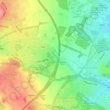
Name: Topografische Karte Nuthall, Höhe, Relief.
Ort: Nuthall, Broxtowe, Nottinghamshire, England, United Kingdom (52.98112 -1.25130 53.01135 -1.20336)
Durchschnittliche Höhe: 95 m
Minimale Höhe: 56 m
Maximale Höhe: 144 m
Andere topografische Karten
Klicken Sie auf eine Karte, um ihre Topografie, ihre Höhe und ihr Relief anzuzeigen.
Manor House Pond
United Kingdom > England > Nottinghamshire > Broxtowe > Bramcote
Manor House Pond, Bramcote Hills, Bramcote, Broxtowe, Nottinghamshire, England, United Kingdom
Durchschnittliche Höhe: 57 m
Beeston
United Kingdom > England > Nottinghamshire > Broxtowe
Beeston, Broxtowe, Nottinghamshire, England, United Kingdom
Durchschnittliche Höhe: 39 m
Nottingham Canal
United Kingdom > England > Nottinghamshire > Broxtowe
Nottingham Canal, Cossall Marsh, Broxtowe, Nottinghamshire, England, NG16 2RU, United Kingdom
Durchschnittliche Höhe: 68 m
Attenborough Nature Reserve
United Kingdom > England > Nottinghamshire > Broxtowe
Attenborough Nature Reserve, Tissington Close, Chilwell Meadows Business Park, Chilwell, Broxtowe, Nottinghamshire, England, NG9 6QG, United Kingdom
Durchschnittliche Höhe: 34 m
Kimberley
United Kingdom > England > Nottinghamshire > Broxtowe
Kimberley, Broxtowe, Nottinghamshire, England, United Kingdom
Durchschnittliche Höhe: 104 m
Cossall
United Kingdom > England > Nottinghamshire > Broxtowe
Cossall, Broxtowe, Nottinghamshire, England, United Kingdom
Durchschnittliche Höhe: 70 m
Strelley
United Kingdom > England > Nottinghamshire > Broxtowe > Strelley
Strelley, Broxtowe, Nottinghamshire, East Midlands, England, United Kingdom
Durchschnittliche Höhe: 100 m
Nottingham Canal Local Nature Reserve
United Kingdom > England > Nottinghamshire > Broxtowe
Nottingham Canal Local Nature Reserve, Moor Lane, Bramcote Hills, Broxtowe, Nottinghamshire, East Midlands, England, NG9 3GP, United Kingdom
Durchschnittliche Höhe: 66 m
Stapleford
United Kingdom > England > Nottinghamshire > Broxtowe
Stapleford, Broxtowe, Nottinghamshire, England, United Kingdom
Durchschnittliche Höhe: 55 m
Giltbrook
United Kingdom > England > Nottinghamshire > Broxtowe
Giltbrook, Broxtowe, Nottinghamshire, England, NG16 2WJ, United Kingdom
Durchschnittliche Höhe: 86 m
Stapleford
United Kingdom > England > Nottinghamshire > Broxtowe
Stapleford, Broxtowe, Nottinghamshire, England, United Kingdom
Durchschnittliche Höhe: 54 m
Greasley
United Kingdom > England > Nottinghamshire > Broxtowe
Greasley, Broxtowe, Nottinghamshire, England, United Kingdom
Durchschnittliche Höhe: 104 m
Eastwood CP
United Kingdom > England > Nottinghamshire > Broxtowe
Eastwood CP, Broxtowe, Nottinghamshire, England, United Kingdom
Durchschnittliche Höhe: 81 m
Newthorpe
United Kingdom > England > Nottinghamshire > Broxtowe
Newthorpe, Broxtowe, Nottinghamshire, England, NG16 2AS, United Kingdom
Durchschnittliche Höhe: 85 m