
Topografische Karte Nanjing
Interaktive Karte
Klicken Sie auf die Karte, um die Höhe anzuzeigen.
Über diese Karte
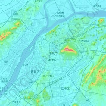
Name: Topografische Karte Nanjing, Höhe, Relief.
Ort: Nanjing, Nanjing City, Jiangsu, 210005, China (31.88377 118.61887 32.20377 118.93887)
Durchschnittliche Höhe: 25 m
Minimale Höhe: 0 m
Maximale Höhe: 430 m
There are mainly two types of soil in Nanjing: zonal soil and cultivated soil. The zonal soil is yellow-brown soil in the northern and central areas of Nanjing, and red soil in the southern part of the border with Anhui. The cultivated soil formed by man-made farming is mainly paddy soil, and there are some yellow Gang soil and vegetable garden soil. The distribution of soil presents a certain law with the undulation of topography and hydrological conditions, which can be divided into three categories: low mountain and hilly area, hilly area and plain area. According to the second national soil survey from 1980 to 1987, the soil in Nanjing is divided into 7 soil types, 13 subtypes, 30 soil genera and 66 soil species, with a total area of 416,300 hectares.