
Topografische Karte Stockbridge
Interaktive Karte
Klicken Sie auf die Karte, um die Höhe anzuzeigen.
Über diese Karte
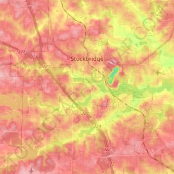
Name: Topografische Karte Stockbridge, Höhe, Relief.
Ort: Stockbridge, Henry County, Georgia, United States (33.47925 -84.29218 33.57271 -84.15969)
Durchschnittliche Höhe: 243 m
Minimale Höhe: 160 m
Maximale Höhe: 283 m
Andere topografische Karten
Klicken Sie auf eine Karte, um ihre Topografie, ihre Höhe und ihr Relief anzuzeigen.
Flippen
United States > Georgia > Henry County
Flippen, Henry County, Georgia, 30253, United States
Durchschnittliche Höhe: 252 m
Peeksville
United States > Georgia > Henry County
Peeksville, Henry County, Georgia, United States
Durchschnittliche Höhe: 197 m
Blacksville
United States > Georgia > Henry County
Blacksville, Henry County, Georgia, United States
Durchschnittliche Höhe: 263 m
Whitehouse
United States > Georgia > Henry County
Whitehouse, Henry County, Georgia, United States
Durchschnittliche Höhe: 230 m
Ola
United States > Georgia > Henry County
Ola, Henry County, Georgia, United States
Durchschnittliche Höhe: 230 m
McDonough
United States > Georgia > Henry County
McDonough, Henry County, Georgia, 30253, United States
Durchschnittliche Höhe: 249 m
Hiram Cook Lake
United States > Georgia > Henry County
Hiram Cook Lake, Henry County, Georgia, United States
Durchschnittliche Höhe: 248 m
Weems Lake
United States > Georgia > Henry County
Weems Lake, Henry County, Georgia, United States
Durchschnittliche Höhe: 245 m
Locust Grove
United States > Georgia > Henry County
Locust Grove, Henry County, Georgia, 30248, United States
Durchschnittliche Höhe: 230 m
Hampton
United States > Georgia > Henry County
Hampton, Henry County, Georgia, United States
Durchschnittliche Höhe: 258 m
McDonough
United States > Georgia > Henry County > McDonough
McDonough, Henry County, Georgia, 30253, United States
Durchschnittliche Höhe: 248 m
Kelleytown
United States > Georgia > Henry County
Kelleytown, Henry County, Georgia, United States
Durchschnittliche Höhe: 220 m